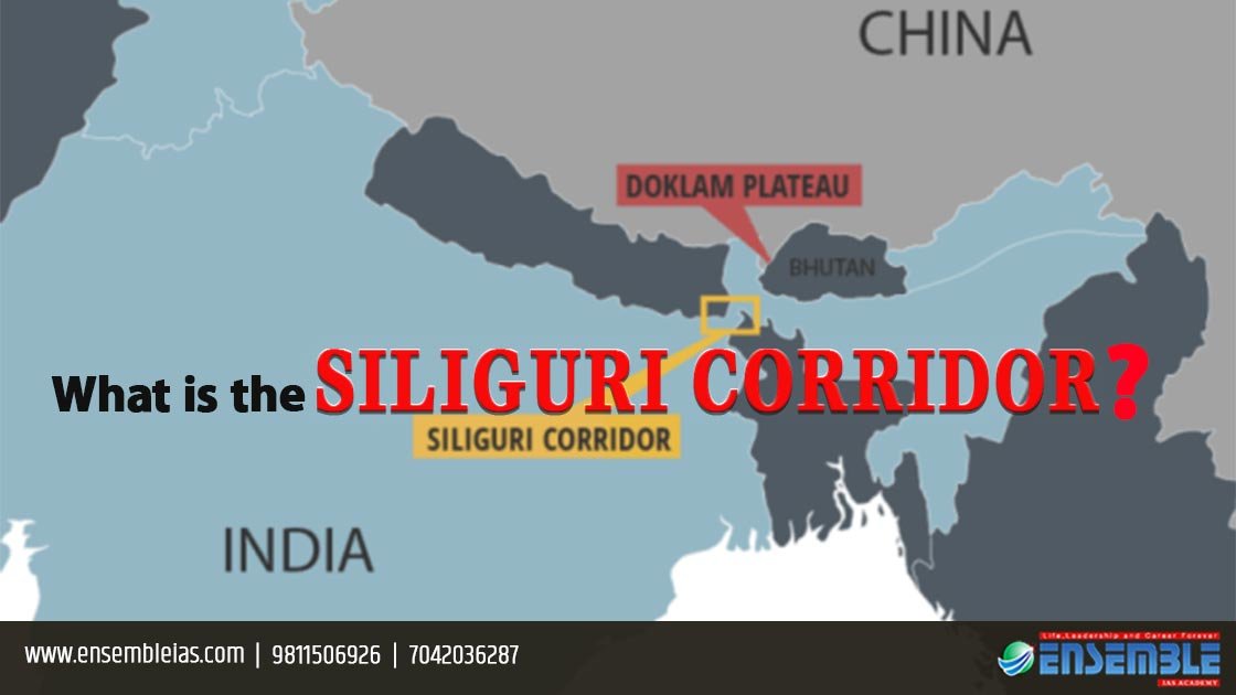
What is the Siliguri corridor?
India’s vulnerable ‘CHICKEN’S NECK’, the Siliguri corridor is the slimmest point, a narrow stretch of about 22 kilometres in the state of West Bengal with the Bangladeshi and Nepalese borders on either side of it, and kingdom of Bhutan in the northern side of the corridor. It connects India’s north eastern states to the rest of India. It is 200 kilometres long and 60 kilometres wide. The corridor extends from the Darjeeling, Jalpaiguri and Terai areas of West Bengal to the north east. This area is important for trade, commerce and tourism for West Bengal, Sikkim, Assam, Nepal, Bhutan and Bangladesh.
 History
The Siliguri Corridor is a cartographic remain of the British decolonization process. The British Empire partitioned British India along religious lines to create modern states of India and Pakistan (divided into east and west Pakistan), it drew lines that lead to Siliguri as a contiguity between Bengal and Assam. With the creation of east Pakistan i.e. Bangladesh in 1971, a choke point was created in India’s geography.
Importance of the area
The Siliguri corridor, a narrow passage to India’s north eastern states is the only link between the seven sisters and the mainland of India. It has a hub of rail and road network which the strategic military formations along the Line of Actual Control (LAC). All the land transportation between India’s mainland and its north eastern states takes place using this corridor, owing to a lack of free trade between India and Bangladesh. All the transportation takes place via a single line railway. The harsh topography of the region makes the railway and roads subject to landslides and natural disasters. The north eastern states are also known for their record breaking levels of rainfall which further adds to the complexity of the situation.
Threat to national security
 Siliguri is at the top of the list of India’s strategic anxieties. India and China have always been in a dispute with each other over the demarcation of the line of actual control. The region has been a constant source of cross border tension due to icy relations with China. For the past three decades, China, unlike India, has consistently built its border infrastructure including railway lines, strategic airfields and roads that can bear the weight of heaviest vehicles, leading right up to the LAC. This is aimed at ensuring quick mobilisation of troops in the event of a possible conflict with India. China would easily bypass and drop special forces to choke vulnerable Siliguri corridor and cut off the north east. Acknowledging India’s national security, the state has thus maintained a heavy patrol presence in Siliguri. The Indian Army, the Assam Rifles, the Border Security Force and the West Bengal Police all patrol the region. India’s Research and Analysis Wing (RAW) is known to closely observe the Nepalese, Bangladeshi and Bhutanese activities in the region as well. The region is also vulnerable to the illegal immigration from Bangladesh in India. Pakistan’s Inter Service Intelligence (ISI) has attempted to exploit Siliguri by Nepal-based insurgents. The Siliguri corridor’s vulnerability is a cruel feature of India’s political geography.
Current situation
 The Doklam plateau is the area where the boundaries of Bhutan, India and China meet. India and China are engaged in a face-off in an area close to Sikkim. The face-off followed by Indian troops is the opposing of the construction of a road by the Chinese in the Doklam plateau. This road will shorten the distance of the Chinese army towards India’s vulnerable chicken’s neck. This would strangle the corridor and cut off the north east from the rest of India. The Siliguri corridor also feeds the primary military formations in the north east. If the corridor is blocked it will lead to the isolation of the crucial military formations, cutting off supplies and reinforcements to them.
Conclusion
The Siliguri Corridor is thus a terrifying vulnerable artery in India’s geography. The fact that China is ready to face off India over border issues on a regular basis is a cause of concern for India. It requires constant dedication on the border areas and stop the development of the infrastructure by the Chinese which would provide long term security. India needs to look for a permanent solution for the china problem so that it can move on devoting time to more of its budget and resources resolving the internal issues. On the bright side, the condition is much better than the past and can be improved with the establishment of a free trade between the states bordering Siliguri.
For more details : Ensemble IAS Academy Call Us : +91 98115 06926, +91 7042036287
Email: [email protected] Visit us:- https://ensembleias.com/
#data_the_new_oil #national_security #pla #artificial_intelligence #social_media #evangelism #fake_news #wikipedia #nsa #Intellectual_property_threat #blog #geography_optional #upsc2020 #ias #k_siddharthasir #Government_of_India #india #studyabroad #geography #upsc #bhugol #government #news #dailynews #gk #dailyquiz #editorial