

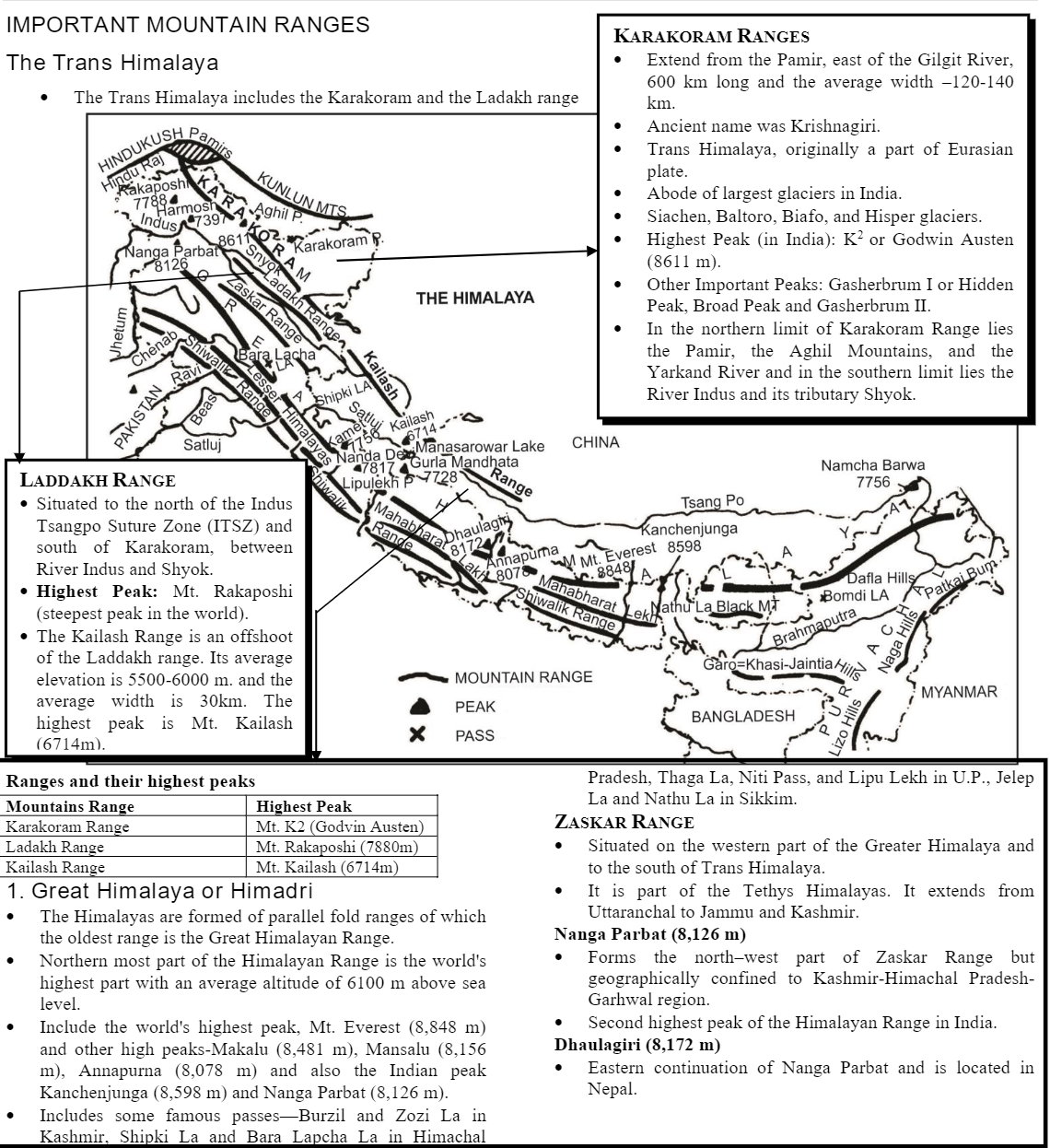
INDIA PHYSICAL
INTRODUCTION
| MOUNTAIN PEAKS | HEIGHT | LOCATION |
| Mount Everest | 8,848m | Nepal |
| Kanchenjunga | 8,598m | Sikkim, India |
| Makalu | 8,481m | Nepal |
| Choyu | 8,201m | Nepal |
| Dhaula giri | 8,172m | Nepal |
| Manasalu | 8,157m | Nepal |
| Nanga Parbat | 8,126m | Jammu and Kashmir, India |
| Annapurna | 8,078m | Nepal |
| Himalchuli | 7,893m | Nepal |
| Nanda Devi | 7,817m | Uttaranchal |
| Kamet | 7,756m | Uttaranchal |
| Namcha Barwa | 7,754m | Arunachal Pradesh, India |
| Churen Himal . | 7,371m . | Nepal |
| Ganesh | 7,163m | Nepal |
| Badarinath | 7,138m | Uttaranchal, India |
| Gaurishankar | 7,139m | Nepal |
| Api Himal | 7,134m | Nepal |
| Nunkun | 7,135m | Jammu and Kashmir, India |
| Saipal | 7,040m | Nepal |
| Nanda Kot | 6,861m | Uttaranchal, India |
List of Himalayan Peaks from west to east direction.
1. Nanga Parbat 2. Nunkun 3. Kamet 4. Badarinath 5. Nanda Devi 6. Nanda Kot 7. Api Himal 8. Saipal 9. Churen Himal 10. Dhaulagiri 11. Annapurna 12. Manasalu 13. Himalchuli 14. Ganesh 15. Gaurishankar 16. Choyu 17. Mount Everest 18. Makalu 19. Kanchenjunga 20. Nancha Barwa.
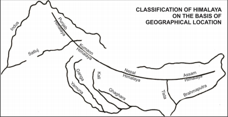
CLASSIFICATION OF HIMALAYA ON THE BASIS OF GEOGRAPHICAL LOCATION
| NAME | LOCATION | DISTANCE |
| Punjab Himalaya | Between Indus and Satluj | 560 km |
| Kumaon Himalaya (Nanda Devi peak forms a part of Kumaon Himalayas located in Uttarakhand.) | Between Satluj and Kali | 320 km |
| Nepal Himalaya | Between Kali and Tista | 800 km |
| Assam Himalaya | Between Tista and Dihang | 720 km |
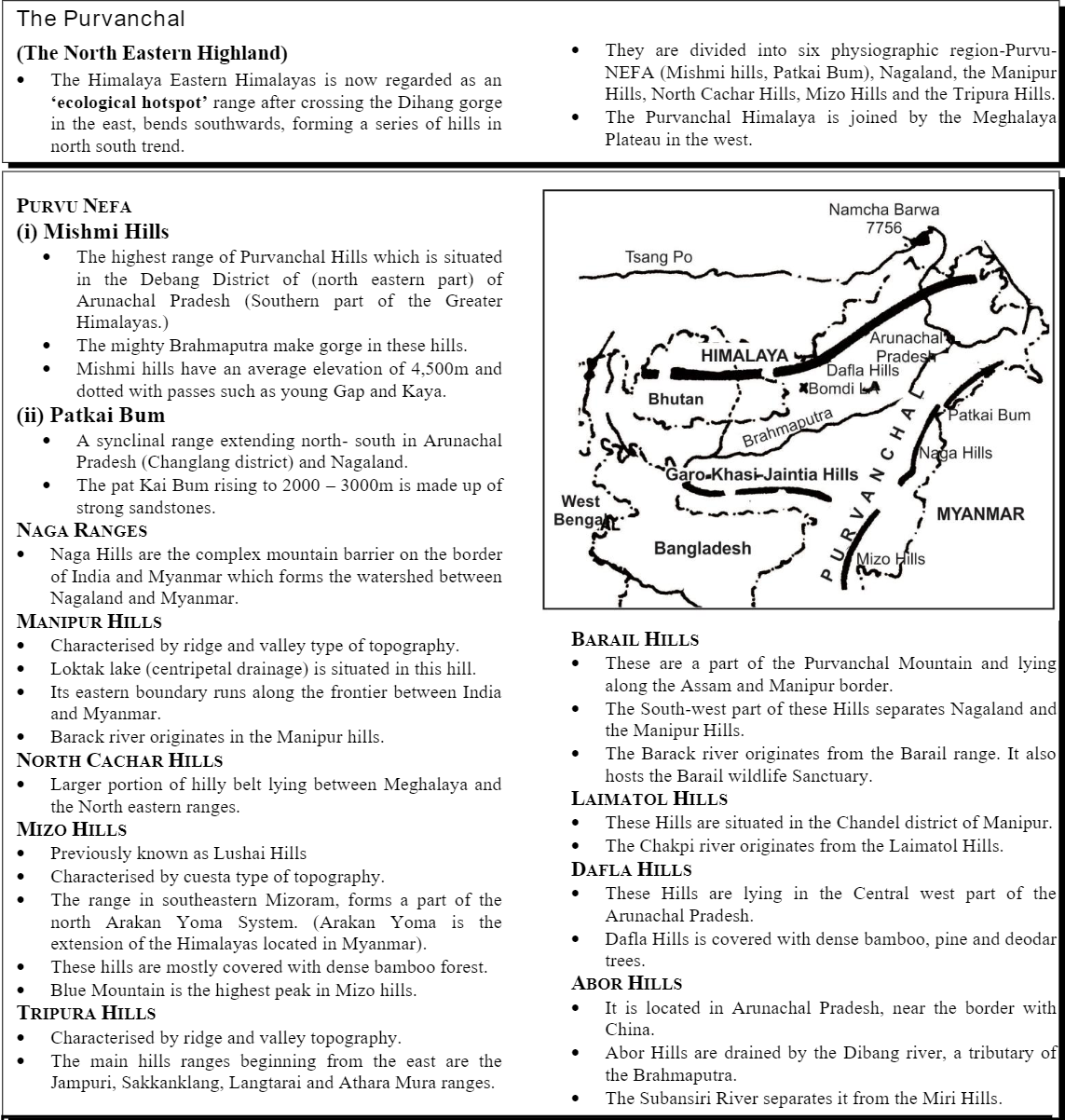
The Purvanchal
East-west extent
2,400 km (3,200 km if the Indus plains are included)
Average width: 150-300 km.
• Largest alluvial tract of the world, extending from the mouth of Indus to the mouth of Ganga between Peninsular plateau and the northern arc of the mountains.
• Alluvial in nature, and are composed of Bhangar (old alluvium), Khadar (new alluvium) in river bed, Bhabar (porous gravel ridden plains at the foot of Himalaya) and Terai (damp, thickly forest area, where bhabar stream reappears).
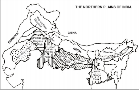
SUBDIVISION OF GREAT PLAINS
| THE RAJASTHAN PLAIN
Extent: 650 km long. Average width: 250-300 km wide. |
• Thar or Great Indian Desert is the westernmost region of Great Indian Plains in the western Rajasthan.
• A semi arid plain, lying to the east of Thar desert is known as Rajasthan Bagar. • The Luni is the only southwest flowing river of this region. • The Sambhar (largest), the Kuchaman, and the Didwana are important lakes situated to the north of Luni Basin. |
| THE PUNJAB HARYANA PLAINS Extent: 640 km from northwest to southeast and 300 km in east west direction. | • Extends from Punjab in the west to Yamuna River (Haryana) in the east. • Land of five rivers-is primary made up of ‘doabs’-the land between two rivers’. • They are composed by Bets (Khadar plains) and Dhaya (Heavily gullied bluffs). |
| THE GANGA PLAINS | • The largest Great Plain stretching from Delhi to Kolkata across the states of Uttar Pradesh, Bihar and West Bengal.
• The Ganga and its tributaries like Yamuna, Ghagra, Gomti, Kosi, Son deposit large amount of alluvium and make this extensive plain more fertile. • They comprise of Ganga-Yamuna Doab in the west, to the east of this Doab are the Rohilkhand plains which merges with Avadh plain in the east. |
| THE BRAHMAPUTRA PLAIN | • The low level plains formed by the Brahmaputra river system is situated between Eastern Himalaya (Arunachal Pradesh) in the north, Patkai and Naga hills in the east, Garo-Khasi Jaintia and Mikir Hills and lower Ganga Plain and Indo-Bangladesh border in the west. |
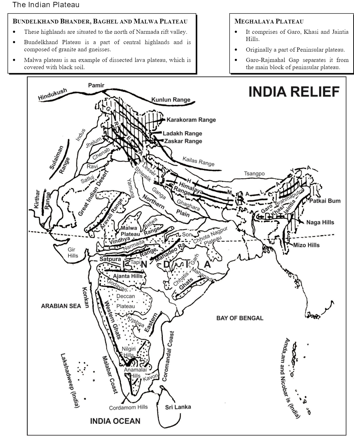
Peninsular Mountains
| THE ARAVALLI RANGE .
Total length: 700 km. Highest peak: Guru Shikhar (1,722 m) on the Abu Hills. |
• Extending from the north east to the south-west of India and separates the semi-desert regions of Rajasthan from the fertile Udaipur and Jaipur regions.
• It is an example of relict mountain. One of the most oldest fold mountains in the world. |
| VINDHYAN RANGE | • A block mountain which separates northern India from the southern mainland. • Composed of sandstones, shales and quartzites.
• Western part of the range is chiefly composed of Basalt. |
| • South of it, Narmada River flows in the rift valley.
• Acts as a natural watershed between north and south India. |
|
| SATPURA RANGE
Highest peak: Dhupgarh (1,350 m) near Pachmarhi. Average elevation: 1,030 m above sea level. |
• Extending in east west direction, to the south of Vindhyans.
• Situated between Narmada and Tapi River. • Starting from Rajpipala hills in the west through Mahadeo hills to Maikal ranges. |
| MAIKAL RANGE | • Eastern part of Satpura system is situated in Madhya Pradesh.
• Mount Amarkantak is the highest peak. |
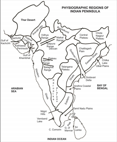
| AJANTA RANGE, BALAGHAT RANGE, AND HARISH CHANDRA RANGE | • Extending in east west direction, are all spurs of Western Ghats forming local watersheds. • Kalsubai (1,646 m), the highest peak of Western Ghat, is located in Harish Chandra Range. |
| NILGIRI HILLS | • It is the meeting point of Western and Eastern Ghats.
• Doda Betta (2,637 m) is the highest peak of Nilgiri Hills. • The hills are separated from southern hills by a gap called Palghat Gap. |
| ANAIMALAI HILLS | • Anai Mudi (2,695 m) , the highest peak of South India is in Anaimalai Hills. |
| CARDAMOM HILLS | • It is situated in the extreme south of Peninsular India.
• Formed of gneisses and schists. |
| RAJMAHAL HILLS | • Extends in north south direction and is situated in the northeastern edge of the Chhotanagpur Plateau. |
| SAHYADRIS (WESTERN GHATS) Total length: about 1600 km. Average height: 1200 m.
Highest Peak: Kalsubai (1646m). |
• Runs along the western coastal plain from the south of valley of Tapi to Kanniyakumari, the southern most point of mainland India.
• The northern section is made up of horizontal sheets of lava, producing a typical trappean like landscape. • The Western Ghats meet with Eastern Ghats in the Nilgiri hills. • Acts as a main watershed of Peninsular rivers. |
| EASTERN GHATS | • Runs along the eastern coast of India from northern Odisha to the Nilgiri Hills. • Characterised by unbroken hills between Mahanadi and Godavari.
• Mahendragiri (1501 m) is the highest peak of Eastern Ghats. • Nallamalai Hills and Velikonda are other prominent ranges. |
CHHOTANAGPUR PLATEAU
Important Gulfs
| NAME | SEPARATES | LOCATION | INFORMATION |
| Gulf of Kachchh | Kachchh and Kathiawar Peninsula | West of Gujarat | Region with highest potential of tidal energy generation. |
| Gulf of Cambay | Kathiawar Peninsula and Gujarat | Gujarat | Tapi, Narmada, Mahi and Sabarmati river drain into the Gulf. |
| Gulf of Mannar | Sri Lanka and Southern India | South east of Tamil Nadu | Asia’s first marine biosphere reserve. |
Important Lagoons and Lakes
| NAME | STATE | INFORMATION |
| Kayals | Kerala | Popularly called backwaters in Kerala, on the Malabar coast. A chain of lakes which are connected with each other by canals. (Peaty soils of backwaters are called Kari in Kerala.) |
| Vembnad Lake
(Largest Kayal) |
Kerala | Large sized backwater of Kerala, have fertile alluvial islands. It is 75 km long and 5-10 km wide enclosed by a spit. |
| Chilka Lake
Maximum length – 64 km Maximum breadth – 20 km Average width – 150 km |
Odisha | Situated to the south west of the Mahanadi Delta.
Enclosed by the sand pit, has an opening which permits sea-connection. Largest brackish water lake in Asia. |
| FRESH WATER LAKES | ||
| Wullar Lake | Jammu and Kashmir | Largest fresh water lake of India. |
| Kolleru Lake | Andhra Pradesh | A part of the sea enclosed between the deltas of Godavari and the Krishna and has a number of islands in it. |
| Pulicat Lake
60 km long and 60 km in the widest part. |
Andhra Pradesh | Situated on the southern border of Andhra Pradesh.
Lagoon formed due to enclosure by sand spit now called Sriharikota islands. |
| Jaisamand Lake | Rajasthan | Largest fresh water lake of Rajasthan. |
| Nakki Lake | Rajasthan | A small natural lake near Mt. Abu surrounded by hills, important as tourist place. |
| Loktak Lake | Manipur | Site of hydroelectricity power generation.
An example of centripetal drainage. |
| SALINE WATER LAKES | ||
| Sambhar Lake | Rajasthan | Largest Lake of Rajasthan lies on the border of Jaipur and Nagaur District.
Sodium chloride (common salt) and sodium sulphate are produced mainly by the Hindustan Salt Ltd. |
| Deedwana Lake | Rajasthan | Situated near Deedwana Town of Nagaur District. |
| GEOGRAPHY THROUGH MAPS 183 |
