DEMO TEST MCQ TYPE
1. An anti-cyclone is a system of wind in which the wind blows spirally
(a) Towards the centre of low pressure
(b) Towards the central region of high pressure
(c) Towards a region of low pressure
(d) Outwards from a central region of high pressure
2. Which of the following explains why there is n total eclipse of the sun?
(a) Size of the sun in relation to the Moon
(b) Direction of rotation of the Earth round the Sun
(c) Orbit of the Moon around the Sun
(d) Size of the Earth in relation to the Sun
3. Match List-I with List-II and select correct answer from the code given below
List-I List-II
A. Atoll 1. Dew Point
B. Crater 2. River
C. Condensation 3. Volcano
D. Denudation 4. Coral Reef
Code
(a) A-1, B-2, C-3, D-4 (b) A-4, B-3, C-2, D-1
(c) A-4, B-1, C-2, D-3 (d) A-4, B-3, C-1, D-2
4. Match List-I with List-II and select correct answer from the code given below
List-I List-II
A. Earthquake 1. Isohyte
B. Rainfall 2. Bora
C. Agulhas 3. Ocean Current
D. Wind 4. Seismic Lines
Code
(a) A-3, B-4, C-1, D-2 (b) A-4, B-1, C-3, D-2
(c) A-2, B-3, C-4, D-1 (d) A-3, B-1, C-4, D-2
5. The surface of the earth is still irregular inspite of millions of years of gradation, because—
(a) Gradation is a slow process
(b) Gradation is differential
(c) Deposition of material re-elevates the land
(d) Parts of the crust have been uplifted
6. What would happen to ocean water if the moon comes nearer to the earth ?
(a) Fall of temperature
(b) Stopping of ocean currents
(c) Rise of sea level
(d) Increase in height of oceanic tides
7. The Savana type of climate is characterized by—
(a) Humid summers and humid winters
(b) Humid summers and dry winter
(c) Humid winters and dry summers
(d) Dry summers and short rainy season
8. Given below are the climate data of a particular station. In which of the following natural regions is the station
located
Temperature Rainfall
Temperature Rainfall
(Degrees Centigrade) (Centimeters)
January 23.3 1.8
February 23.3 1.8
March 21.1 2.5
April 17.8 4.6
May 14.4 7.1
June 12.2 7.9
July 11.1 6.9
August 12.3 6.3
September 13.9 5.1
October 16.7 4.3
November 19.4 3.0
December 27.7 2.5
The above temperature precipitation data refers to
(a) Warm temperate East coast type
(b) Warm temperate West coast type
(c) Warm temperate Continent type
(d) Hot deserts
9. The Scandinavian countries are located in high latitudes. Parts of countries located in the same latitudes freeze
during winter, but the ports located on the Norwegian coast do not freeze.
This is the mainly due to the fact that—
1.Many small rivers drain to the sea
2.There is a chain of volcanoes
3.The North Atlantic Drift flows past the coast
4.The Westerlies blow from the South West bringing warm rain
Of the above, the correct answer is
(a) 1 and 2 (b) 2 and 3
(c) Only 3 (d) Only 4
10. Which of the following statement is correct
1. Wellington the capital of New Zealand is on North Island
2. Cook strait separates North & South Islands
(a) 1 only (b) 2 only
(c) Both 1 & 2 (d) Neither 1 nor 2
11. Arrange the following seas from East to West in Europe.
1. Aral Sea 2. Black Sea
3. Aegean Sea 4. Caspian Sea
Of the above, the correct answer is
(a) 4, 1, 3, 2 (b) 1, 4, 3, 2
(c) 1, 4, 2, 3 (d) 4, 1, 2, 3
12. Consider the following statements and mark the correct statement/s
1. Nile river drains into Mediterranean Sea
2. Volga river drain into Caspian sea.
3. Located on Angars is the world’s highest dam.
4. Russia has interior drainage
Of the above, the correct answer is
(a) 1 and 2 (b) 3 and 4
(c) 2 and 3 (d) 1, 2, 3 and 4
13. The climate of Britain is milder than most other places along the same latitude for which of the following reasons?
(a) The Gulf Stream brings warm waters to Britain, raising the temperature of winds that blow onto the island.
(b) Hot springs throughout the country raise the temperature of the surrounding land and air.
(c) Mountain ranges in the north of Britain act as a barrier to cold winds blowing from the Arctic.
(d) Small landmasses generate their own local climate and are largely unaffected by latitude.
14. One of the effects of the east-west orientation of the Alpine mountain system and the northern plains of western
and central Europe is that it
(a) limits the marine climate of Europe to coastal areas
(b) provides a corridor for communication between southern and northern Europe
(c) enables marine-like climatic conditions to extend eastward into Germany and Poland
(d) effectively prevents population movement between parts of the Mediterranean region
Questions 15 – 18 refer to the hydrological cycle diagram below:
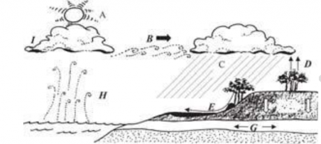
15. Which number refers to the process of precipitation?
(a) H (b) D
(c) I (d) C
16. Condensation would best be illustrated by letter:
(a) C (b) I
(c) A (d) E
17. Name the processes occurring at letter D and F respectively:
(a) evaporation and condensation
(b) evapo-transpiration and infiltration
(c) evapo-transpiration and surface run-off
(d) evaporation and insolation
18. The state of water located at letter H would be:
(a) ice (b) water vapour
(c) liquid (d) all of the above
19. Which pair of statements is incorrect?
(a) i] winds blow in attempt to equalise air pressure
ii] winds are named according to the direction in which they originate
(b) i] the greater the pressure gradient, the stronger the wind
ii] a wind blowing on to the shore is named an onshore wind
(c) i] a wind blowing on to the shore is named an offshore wind
ii] winds are named according to the direction they blow to
(d) i] winds tend to follow the direction of isobars
ii] winds blow in an attempt to equalise air pressure
20. The following diagram of the sun’s rays passing through the atmosphere illustrates
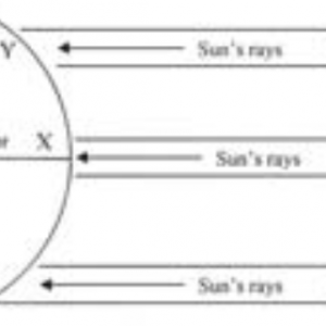
(a) the sun heats up more atmosphere as it passes through to X
(b) sun’s rays are less concentrated at Y compared with X
(c) due to the earth’s curvature, the heating effect increases at Y
(d) the sun’s rays are less concentrated at X compared with Y
Questions 21-24 refer to the diagram below:
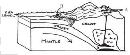
21. The resultant feature formed at location A is a:
(a) volcanic mountain chain
(b) fold mountain range
(c) mid ocean ridge
(d) volcano
22. This feature formed at A has resulted from:
(a) the melting of the subducting oceanic plate
(b) the melting of the subducting continental plate
(c) the scraping of sediment along the continental plate
(d) an increase in pressure within the lithosphere
23. This destructive process involves which two plates?
(a) oceanic & oceanic
(b) continental & continental
(c) continental & oceanic
(d) all of the above
24. The movement of these two plates and the resulting features produced illustrate the destructive process of:
(a) translation
(b) divergence: subduction
(c) convergence: collision
(d) convergence: subduction
25. Consider the following statements regarding mass movement, and select from the code given below
1. Mass movement occurs when gravity causes the downhill movement of rock materials
2. Mass movement is the movement of rock materials to a lower level due to the influence of gravity
3. Mass movement is large scale rock movement, not debris movement
4. Mass movement is the gradual downslope movement of soil due to the lubricational effect of water
Of the above, the correct statements are?
(a) 1 and 2 (b) 2 and 3
(c) 2 and 4 (d) 1 and 3
26. Which of the following is NOT a likely reason for the occurrence of this movement below?
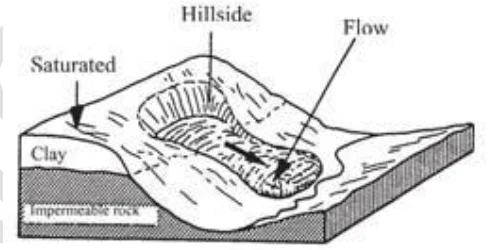
(a) steep land (b) prolonged rains
(c) instability of soils (d) forward tilting bedding planes
27. Which of the following statements is incorrect regarding the nature of water promoting mass movement?
(a) heavy rains contribute to mass movement
(b) as a lubricant, water reduces internal friction of rock particles
(c) water decreases the weight of the overlying regolith
(d) water increased the weight of the overlying regolith
28. Which list correctly identifies features produced through wave erosion?
(a) sea cliff, wave cut platform, sea cave, spit, sea stack
(b) sea cliff, wave cut platform, tombolo, spit, sea stack
(c) natural bridge, sea cave, blowhole, cuspate spit, tombolo
(d) sea stack, natural bridge, blowhole, sea cave, sea cliff
Question 29-30 refer to the cross section of the coastal landscape below:
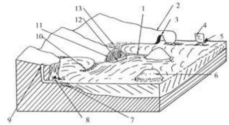
29. Which two coastal features match number 1 and 6 respectively?
(a) spit and island (b) headland and stack
(c) beach and island (d) tombolo and island
30. A wave cut platform corresponds to which number?
(a) 12 (b) 7
(c) 11 (d) 4
Questions 31-32 refer to the plutonic cross section below:
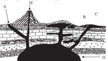
31. What intrusive volcanic feature is illustrated by point A?
(a) dyke (b) batholith
(c) sill (d) laccolith
32. A batholith is represented by which letter?
(a) C (b) D
(c) B (d) E
33. Water may be considered to be which of the following type of resources
(a) Renewable resource because it can be replenished after use
(b) Cyclic resource because it has no final use
(c) Non-renewable because once depleted cannot be easily replenished
(d) Renewable resources as it can be cloud seeded
34. Which of the following may be cited as causes for de-industrialisation.
1. Machinery replacing people in most manufacturing industries
2. Prices being too high due to low labour productivity
3. Highly qualified people preferring tertiary and quaternary sectors
4. International competition
Of the above, the correct answer is
(a) 2 and 3 (b) 2 and 4
(c) 2, 3 and 4 (d) 1, 2, 3 and 4
35. The main difference between location of petrochemical industries of USA and Europe is which of the following
(a) European petro-chemical complexes are located near coastal areas while those of USA near markets
(b) European petrochemical complexes are located only around Rhine valley while those of USA along ST. Lawrence.
(c) European petrochemical complexes are located near markets while those of U.S.A. near coastal locations
(d) European petrochemical complex are market driven, while American are raw material oriented .
36. Match the following minerals with their major producing centres
List-I List-II
A. Iron ore 1. Mexico
B. Copper 2. Malaysia
C. Silver 3. CIS
D. Tin 4. Chili
Code:
AB C D
(a) 1 3 4 2
(b) 3 1 4 2
(c) 3 4 1 2
(d) 4 1 2 3
37. Match the following foragers (List-I) with their areas of habitats (List-II).
List-I List-II
A. Pintupi 1. Malaysia
B. Paliyan 2. Australia
C. Toba 3. Brazil
D. Semang 4. Southern India
Code:
A B C D
(a) 2 4 3 1
(b) 4 2 3 1
(c) 3 2 1 4
(d) 2 3 1 4
38. Wheat is most widely distributed crop in the world. Which of the following may be considered to be the most
important reason behind this.
1. Wheat is staple food for most of people around the world.
2. The cost of production is cheap
3. 50% of land surface receives annual rainfall between 25-100cm.
4. Wheat has highest protein content amongst all the food grains
The correct answer is
(a) 1 and 2 (b) 2 and 3
(c) 3 and 4 (d) 1, 3 and 4
39. Which of the following statement is/are correct
1. Subsistence agriculture is the most widespread form of agricultural production.
2. Its a way of life for almost half of the World’s population.
Of the above, the correct answer is
(a) 1 only (b) 2 only
(c) Both 1 & 2 (d) Neither 1 nor 2
40. Consider the following statement. Which one of the following is correct
1. The Black forest is a wooded mountain region in South western Germany
2. Its name refers to the heavy stands of Fir on the upper slopes
Of the above, the correct answer is
(a) 1 only (b) 2 only
(c) Both 1 & 2 (d) Neither 1 nor 2
41. Consider the following statement about South America. Which out of the following is correct
1. It is the fourth largest continent.
2. The parched Atacama Desert of Northern chile is one of the driest place in the world.
Of the above, the correct answer is
(a) 1 only (b) 2 only
(c) Both 1 and (d) Neither 1 nor 2
42. Consider the following statements about New Zealand and state which is/are correct.
1. The Taranki plain in northern Island has the highest density of milk cows in the world
2. Geographically New Zealand is far located from the market of milk products that is why milk is converted into
high value milk products
Of the above, the correct answer is
(a) 1 only (b) 2 only
(c) Both 1 & 2 (d) Neither 1 nor 2
43. The regional variation in the appearance of humans in clustered populations probably results
(a) from a long history of adaptation to different environments.
(b) development of populations on different continents.
(c) wars kept populations separated.
(d) territoriality kept people from mixing and intermarryin
44. Coal is an essential energy resource for industries. However, some countries have been able to achieve
industrialization without depending on coal as a source of energy. For example
(a) Poland and Switzerland
(b) Switzerland and Holland
(c) Sweden and Italy
(d) Brazil and South Africa
45. The present day search for fuels alternative to petroleum, is due mainly to
1. Iran-Iraq war
2. Strained relations between Israel and Middle East countries
3. Highly increased cost of petroleum
4. Increase in the consumption of petroleum
5. Increasing demand and increasing conflict associated with petroleu
Of the above, the correct answer is
(a) 1 and 2 (b) 2 and 3
(c) 1, 2and 5 (d) 4 and 5
46. For the production of wheat there should be—
1. Cool and wet climate during its growing period but hot climate during the ripening period
2. Sufficient heat but very little rainfall
3. Sufficient heat and heavy rainfall
4. Hot climate during the growing period but cool climate during the ripening period
Of the above, the correct answer is
(a) 1 and 2 (b) 2 and 3
(c) 3 and 5 (d) 1, 2 and 3
47. A hypothetical country has a population of 1,000, of whom 500 live in urban areas and 500 in agricultural areas. The
country has a total area of 200 square miles with 50 square miles of arable land. What is the arithmetic density?
(a) 1 per square mile (b) 4 per square mile
(c) 5 per square mile (d) 40 per square mile
48.As a country’s economy develops, a smaller percentage of the workforce tends to be employed in
(a) agriculture, because industrialization decreases the value of rural land
(b) agriculture, because investment in technology increases yields and decreases labor demand
(c) industry, because the profit from extracting natural resources increases
(d) industry, because productivity increases as labor costs rise
49. Water power potential of India is great, but it has not been developed to its full extent. The major deterrant being
that—
1. Coal is available in plenty therefore it is not necessary to develop water power
2. Raw materials required for the production of electric transformers are not available in India
3. Rainfall is seasonal and as such requires costly storage reservoirs
4. Lack of technical skill hinders the development of water power
5. Initial investment required is huge.
6. Hydel power is site specific
Of the above, the correct answer is
(a) 1, 3 and 4 (b) 2, 3 and 6
(c) 2, 3 and 5 (d) 1, 4, 5 and 6
50. One of the characteristics of India’s population is lesser number of women compared to men. Which one of the
following explains this phenomenon?
(a) Excess males at birth
(b) Lower social status of women
(c) Neglect of females in childhood
(d) High maternity mortality
51. The basic unit of settlement recurring throughout India is the village. Which of the following criteria is largely
responsible for the selection of village sites?
(a) Behavioural patterns of the community
(b) Availability of flat land
(c) Essential resources like water and fuel
(d) Fuel resources and building materials
52. Which one of the following factors accounts largely for the dispersal of cotton textile industry from its original
location around Mumbai?
1. The development of transportation, especially railways
2. Extreme congestion in Mumbai and lack of space
3. The development of hydro-electric power
4. Improved technology in providing humidity
The correct answer code is:
(a) 1, 2 and 3 (b) 2, 3 and 4
(c) 1, 3 and 4 (d) All of the above
53. The reason NOT necessary for irrigation in India is that—
1. There is no rainfall at the time of need
2. Indian crops require much water
3. Indian farmers are in habit of watering the fields
4. India is a hot country so water is easily evaporated
5. India presents spatio-temporal variation in rainfall.
6. The variability is high and reliability is low
Of the above, the correct answer is
(a) 1, 2 and 3
(b) 1, 3 and 5
(c) 2 and 5
(d) 3, 4, 5 and 6
54. The number of wells in South India is very low because—
1. The people of South India do not like to take water from wells
2. Wells are difficult to dig because of hard rock underneath the thin layer of the soil
3. There is too much rainfall therefore wells are not needed
4. The people of South India do not know how to dig wells
5. The water table is unlike Gangetic Plain.
Of the above, the correct answer is
(a) 1, 2 and 3
(b) 1 and 5
(c) 2 and 5
(d) 2, 3 and 4
55. If Aravalli ranges were from east to west—
(a) There would be no difference at all
(b) Bengal would have been the dry area
(c) The western Rajasthan would never have been a desert
(d) Uttar Pradesh would have been a desert
56. The biggest number of jute mills in India is in West Bengal because—
(a) This is the region of raw materials for jute products
(b) The climate is suitable
(c) It is near the consuming area
(d) Cheap supply of labour is available here
57. Natural vegetation of a region depends mainly on climate and hence there are distinctive areas of different types of
vegetation. The governing factors in general are temperature, and precipitation. Accordingly, pine forests in India
are found in—
(a) The Sundarbans
(b) The Thar desert
(c) The Himalayas
(d) The Ganga plain
60. Which of the following statements does not prove the sphericity of the earth?
(a) One does not come across any sharp edges on the earth
(b) The time of sunrise varies from place to place
(c) The earth casts a spherical shadow during solar eclipse
(d) Altitude of the polestar varies according to latitude.
61. On the surface of the moon
(a) the mass of an object is more but it weights lesser
(b) the mass and weight both remain unchanged
(c) the mass is the same but the weight is lesser
(d) the mass is more but the weight is lesser
62. Why do we always see the same face of the moon?
(a) Because the moon takes the same time in completing one revolution around the earth and one rotation on its axis.
(b)Because the moon takes the same time in completing one rotation on its axis and one revolution around the sun
(c) Because the moon is smaller than the earth
(d)Because the moon rotates on its axis in a direction opposite to that of the earth.
63. In what respect oceanic crust differs from the continental-?
1. Physical structure
2. Composition of rocks
3. Uniformity of surface
4. Density of rocks
Of the above, the correct answer is
(a) 1 and 2
(b) 2 and 4
(c) 1 and 4
(d) 2, 3 and 4
64. One of the causes of low pressure in the subpolar regions is
1. Ratification of atmosphere due to air flow to poles.
2. Very low temperature with low humidity.
3. Large amount of insolation during the summer season.
4. Convergence of air from poles and tropical regions.
5. Increasing radius with respect to air coming from poles.
Of the above, the correct answer is
(a) 1 and 2
(b) 2 and 3
(c) 3 and 4
(d) 4 and 5
65. Mark the correct order or pressure belts from equator to poles.
(a) Equatorial low-Subtropical high-polar high-subpolar low
(b) Equatorial low-Subpolar lo-Plar high-Subtropical high
(c) Equatorial low-Subtropical high-Subpolar low-Polar high
(d) Subtropical high-Equatorial low-Subpolar low-Polar high
66. What are signs of rejuvenation in a stream valley
1. Entrenched meanders
2. Ox-bow lakes
3. Nick points
4. Terraces
The correct answer is
(a) 1, 2 and 4
(b) 1 and 4
(c) 2, 3 and 4
(d) 1, 3 and 4
67. Which of the following is NOT one of the reasons for the concentration of Jute in a small area in India?
(a) Availability of water and high atmospheric humidity.
(b) Comparatively flat topography
(c) Alluvial soil and abundances of cheap labour
(d) Availability of capital
68. Which statement about the Siwaliks is NOT correct?
(a) They are also known as outer Himalayas
(b) These are made of unconsolidated river deposits and are prone to earthquakes and land-slides
(c) Soil erosion is at its worst in the Sivaliks
(d) Their average elevation is 400 mts
69. All the following statements are true except
(a) The hard woods are most suitable for furniture, wagons, tools etc.
(b) The soft woods are well suited for conversion into paper pulp and are best for constructional timbers, studs etc.
(c) 70% of soft wood yield goes to industrial uses whereas 70% of hardwood is burnt
(d) Indian forests contain over 5,000 species of wood, of which about 2000 are commercially valuable
The questions 70-84 are assertion reasoning based to answer the question follow the directions
The following 13 (thirteen) items consist of two statements, one labelled as `Assertion A’ and the other labelled as
`Reason R’. You are to examine these two statements carefully and decide if the Assertion A and the Reason R are
individually true and if so, whether the Reason is a correct explanation of the Assertion. Select your answers to these
items using the codes given below and mark your answer sheet accordingly
Codes:
(a) Both A and R are true and R is the correct explanation of A
(b) Both A and R are true but R is NOT a correct explanation of A
(c) A is true but R is false
(d) A is false but R is true
70. A: The production of mica has shown a declining trend in India in 1970s and 1980s
R: This decrease is the result of the fall in its demand in the international market
70. A: Sugar industry is raw-material oriented industry
R: Sugar cane is a weight loosing raw-material
71. A: Major industrial regions in India have developed in the immediate hinterlands of the ports of Calcutta,
Bombay and Madras
R: The Ports provided access to the raw materials found in their hinterlands as well as to the world market.
72. A: The Ahmedabad-Vadodra became and important textile region
R: The cotton textile industry declined in Bombay due to the higher transportation cost of bringing cotton from
peninsular parts of India.
73. A: The continents are dries in their subtropical areas towards their western part
R: Upwelling causes cold currents towards western part.
74. A: A readily available market is an essential requirement for generating HEP.
R: Electricity can not be stored
75. A: Australia occupies the second place after the Brazil in iron ore reserves
R: Brazil is a craton while Australia is a shield.
76. A: Land water, livestock, forest, minerals and well as human beings are resources
R: Appropriate technology is available for its transformation into more valuable goods.
77. A : The highest temperatures are observed at the Equator.
R : The sun shines vertically at the Equator
78. A: The early atmosphere was an oxygenic
R : The early atmosphere was having 99.98% of CO2.
79. A: The tropical cyclones are very strong in the autumn rather than summer.
R : The ocean waters are warmest during autumn rather than summers.
80. A: The western depressions are almost invariably followed by high pressure anticyclones
R : The jet streams converge and diverge at the subject.
81. A: Thundershowers are followed by clear clouds.
R ; Thundershowers form from cumulonimbus clouds which disperses after rains.
82. A: Patagonia is the driest desert of South America.
R : Patagonia lies in the leeside of the Andes.
83. A : Corals live in symbiotic relation with the zooxanthellae.
R : The decay and death of the zooxanthellae
84. A: A plants have leather like leafs in equatorial regions.
R : The equatorial regions receive heavy torrential showers
85. Irrigation facilities are difficult to create in the Himalayan regions, because of
(a) The difficulty in digging channels from the nearby rivers
(b) Non-availability of sub-soil water
(c) The inclined surface of mountain slopes
(d) There being no rivers near the cultivable land.
86. Sheet erosion is common on …………….in the heavy rainfall areas.
(a) Plain surface
(b) Steeper slopes
(c) Undulated surface
(d) None of these
87. The first phase of Himalayan building was marked by the upliftment of the
(a) Siwaliks
(b) Central Himalayan axis
(c) Warping up of the sediments deposits
(d) None of these
88. The season ‘Shishira’ corresponds to the months of English calendar are
(a) March-April
(b) January-February
(c)November-December
(d) None of the these
89. Nathu La and Jelep La passes lead from
(a) Afghanistan to Kashmir
(b) Gilgit to Leh
(c) Sikkim to Tibet
(d) Plains to Punjab to Gilgit
90. The Sex-ratio of any areawill be greatly influenced by
(a) The effects of migration
(b) The preponderance of male births
(c) The differential mortality rates of the two sexes
(d) All of the above
91. ‘Infant mortality’ is defined
(a) The nos. of deaths of infants per thousand live births
(b) The nos. of deaths of infants under the age of 2 years expressed per thousand live births.
(c) The nos. of deaths per thousand infants
(d) The nos. of deaths of infants under the age of one year expressed per thousand live births.
92. What happens when a cyclone passes over an area?
1. There is quick change in pressure
2. Gusty winds
3. Heavy and torrential rain
4. Dry weather
Of the above, the correct answer is
(a) 1, 2 and 4
(b) 1, 3 and 4
(c) 1, 2 and 3
(d) 2, 3 and 4
93. The causes of low pressure in the equatorial region is
(a) High temperature
(b) Air convergence
(c)High humidity
(d) Strong centrifugal tendency
(a) Only 1
(b) 1, 2 and 4
(c) 1 and 4
(d) All four
94. Match the following:
List-I List-II
A. Temperature falls with height 1. Ionosphere
B. Reflects radio waves back toearth 2. Stratosphere
C. Contains most of the ozone 3. Tropopause
D. Fall in temperature stops 4. Troposphere
Of the above, the correct answer is
A B C D
(a) 4 2 1 3
(b) 3 2 4 1
(c) 4 1 2 3
(d) 4 3 1 2
95. A playa is –
(a) An area receiving sediment through wave deposition
(b) An area from where the winds have eroded a lot of rocks
(c) An area receiving sediments in a semi-arid region
(d) An area eroded extensively by glaciers
96. The earliest formed crust was made of
(a) Basalt
(b) Granite
(c) Greenstone
(d) Granodiorite
97. The major reason for launching of CAPP was
(a) Improve the quality of water
(b) Improve the quantity of water retentity
(c) Improve the supply of inputs
(d) Bridge the gap between potential created and utilised.
98. The common between Yelahanka, Ibrahimpatnam, Shamshabad, Panchkula is, that they are all
(a) Airports
(b) Greenfield sites
(c) Townships
(d) Satellite towns
99. The western portion of W. Ghats are, while the E. portion is _______________ and made of _____________
(a) Step like, steep, granite
(b) Rolling, strep, andesite
(c) Steep, step like, basalt
(d) Step like, steep, basalt
100.On a bright summer day as one moves from Delhi over Rajasthan by air they will observe a _______ effect looking
down which will be indicative of the presence of—–
(a) salt, gypsum
(b) shinning, salt
(c) glistening, gypsum
(d) glistening, salt


