DISCUSS THE SUPERCONTINENT CYCLE, ITS CAUSES AND THE FUTURE OF THE WORLD.
The only thing that is constant in nature is change. The various feature found on the ocean basin are not permanent. For example, the Pacific ocean is closing because the Pacific plate is subducting very fast beneath the Eurasian plate. The ocean basins emerge from the fragmentation of two continents, enlarge and expand, andeventually close. This process of openining and closing of the ocean basin is called formation of Supercontinent or Wilson cycle.
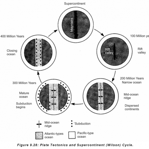
The only thing that is constant in nature is change. The various feature found on the ocean basin are not permanent. For example, the Pacific ocean is closing because the Pacific plate is subducting very fast beneath the Eurasian plate. The ocean basins emerge from the fragmentation of two continents, enlarge and expand, and eventually close. This process of openining and closing of the ocean basin is called formation of Supercontinent or Wilson cycle.
Figure 9.28: Plate Tectonics and Supercontinent (Wilson) Cycle.
Earth has been cooling since its formation. Since the crust formed, Earth has undergone seven or eight cycle of Supercontinent formation. Supercontinent break up, forming a new ocean, which grow and later disappear, forming another Supercontinent. The cycle from start to finish, takes about 500 million years.
The cause of the formation and breaking of the Supercontinent are thought to be driven by process in the mantle. As the mantle warms, it expands, elevating the overlying continent and stretching its crust. Eventually, the crust breaks, forming a rift valley. This is what is appearing in Africa, which has been its present location for about 200 million years and stands about 400m higher than other continents. As the rift grows, a long ocean basin forms. As the rift enlarges and divergence takes place, the narrow ocean basin bordered by continental margin, widens and along the line where rift developed magma comes from below and solidifies forming an ocean ridge. As more and more material is added on to the ocean ridges by upwelling from below, the ocean floor spreads and the ocean basin widens. To accommodate this widening subduction occurs. Eventually, the ocean basin begins to close as subduction overwhelms spreading due to mid oceanic ridge. In the intial stages of the ocean basin closing, subduction of one plate causes the development of island arcs and trenches around the ocean basin. The Pacific Ocean represents this stage.
As subduction proceeds, the ocean basin narrows down forming irregular seas with young mountains. The Mediterranean represents this stage. It is in its terminal stage of closing.
19. DISCUSS, THE SUPERCONTINENT CYCLE, ITS CAUSES AND THE FUTURE OF THE WORLD.
⦁ What it is
⦁ Who gave it
⦁ Meaning →Opening & closing of ocean plate
⦁ Event Associated → Opening→ break up of Pangea
Future
1. Mediterranean closes
2.Rupture of Russia (lake Baikal line)
3. California separates
4. N.America. Asia & Africa become One
5⦁ DISCUSS THE TEMPERATURE DISTRIBUTION IN OCEANS, BOTH HORIZONTALLY AND VERTICALLY.
The temperature distribution in oceans is determined by a combination of factors that determine the input of solar energy, its distribution and reradiation back into space from the ocean surface.
Patterns of sea surface temperature over the open ocean show values ranging from freezing point (about –1.9°C at a salinity of 35‰) to some 30°C. The seasonal range of temperature is widest in middle latitudes, and greater in the Northern Hemisphere than in the Southern Hemisphere, essentially due to the large amount of land in middle latitudes in the Northern Hemisphere. The greatest seasonal contrast is in the North Pacific, where the mean range along 40°N is almost 10°C. Further, the mean position of the zone of maximum temperature, the thermal Equator, is displaced to about 5°N. This, too, stems from the distribution of land and sea in the two hemispheres, and in particular from their effect on oceanic circulation and from the high albedo of the Antarctic continent. The path of the ocean currents which contribute to the poleward advection of heat (e.g., the Gulf Stream in the western North Atlantic) stand out clearly by their marked positive temperature anomalies for their latitude.
Isotherms do not, however, run parallel to lines of latitude. In summer they are displaced polewards over continents (i.e., air temperatures are higher over land masses), whereas in winter they are displaced towards the Equator over continents (i.e., air temperatures are higher over the ocean). Mean annual air temperature anomalies from the mean for a given latitude indicate essentially the effects of advection. These anomalies reach positive values of more than 10°C over the northeast Atlantic due to the advection of heat by the Gulf Stream and North Atlantic Drift as well as in the atmosphere, contrasting with negative values of 4 to 5°C in the neighbourhood of Labrador, in similar latitudes on the opposite side of the North Atlantic.
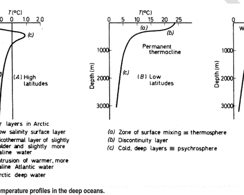
The vertical distribution of temperature shows differing patterns in differing latitudinal regimes.
14. Discuss the Mechanism of transformation processes of soil. How does this affect soil fertility?
Transformation process of soil formation include in sites transformation of the soil without involving any movement of the material. These process include decay of organic matter, weathering of primary and secondary mineral and net loss of mass and energy that accompanies such process. Transformation process mainly include biological activity. Living plants and animals life with the soil also influences soil formation and fertility.
Living plants contribute to soil formation in two basic ways- first in the production of organic matter both above and within the soil and second, by taking up of variety of nutrient from the soil.
Role of animal is extremely important in soil transformation e.g., micro-organisms like algae, funge, and bacteria break down humus, rhizobium cause nitrogen fixation. Algae, when in sufficient member, form a crust preventing soil erosion, contribute to organic matter and initiate carbon and nitrogen cycles. Micro-organisms like actinomycites is very important decomposers of organic matter. Decomposers animals and plants, add humus to the soil. This increase soil fertility.
48. The balance of perception is the best indication of among all Social Well being indicators of the people of the country. Comment
‘Social Wellbeing’ is concerned with ensuring people have ‘a voice in their future, a choice in their lives, and identity’. Generally, social wellbeing refers to the ability to interact successfully within a community and through variety of cultural context while showing respect. It encompasses interpersonal relationship, social support network, and community engagement. As a member of a community one should not be biased, must have balance of perception, meaning not having extremes of viewpoint, and additionally they develop satisfying relationships, a capacity for intimacy, an understanding of self in relation to others, and a sense of belonging. To achieve Social Wellbeing, there is a need to acquire the skills to communicate effectively, resolve conflicts, transcend differences and provide leadership in community. Social Wellbeing is interwoven into other dimensions of wellbeing through an emphasis on orienting the individual within a community context.
Social Wellbeing involves :
⦁ Dignity and Self Determination, i.e., the recognition of the uniqueness and worth of each individual, each family, each community.
⦁ Participation, Belongingness and Development of potential platform like work enable people to participate, have a sense of belonging and which allows them to support themselves with dignity and to develop the potential.
⦁ Fair distribution of wealth and resources.
⦁ Tolerance and respect for cultural diversity.
⦁ And above all the will and the ability to differentiate emotions, balance viewpoints, balance perception, rationalise behaviour, defend statements backed up with topic and reason as well as the ability and the will to accept critical points, be responsive towards criticism and maintain dignity.
7⦁ Differentiate between globalisation and glocalisation and the relative suitability of the terms to world economic management.
Globalisation is defined as the growing interdependence of countries worldwide through the increasing volume and variety of cross-border transactions in goods and services and involves international capital flows, and through the more rapid and widespread diffusion of technology.
In contrast, Glocalisation is a term that was invented in order to emphasize that the globalisation of a product is more likely to succeed when the product of service is adapted specifically to each locality or culture it is marketed in. The increasing presence of McDonalds’s restaurants worldwide is an example of globalisation, while the changes in the menus of the restaurant chain that are designed to appeal to local tastes are an example of glocalisation.
Globalisation aims at a worldwide intra-firm division of labour. In this strategy, activities are established in many sites spread over the world, based on a country’s comparative advantages. A manufacturer striving for globalization aims to secure the supply of its inputs by locating production of these inputs at the most favourable locations. Thus, labour-intensive production of components will be situated in low-wage areas, while the production of high-tech and high value-added parts will require a skilled or well-educated workforce. In a European context, this would mean locating research facilities in core areas and assembly plants in peripheral areas.
Glocalisation aims to establish a geographically concentrated inter-firm division of labour in the three main trading blocs: Japan and South-East Asia, the USA, and the EU – collectively these are known as the Triad. Manufacturers striving for glocalization are building their comparative advantage on close interaction with suppliers and dealers, as well as with other relevant actors, such as banks and governments. Two essential elements stand out in a firm’s glocalization strategy:
o the decentralization of production to hierarchical networks of local subcontracting
o a high degree of control over supply and distribution.
Despite the fact that Indian Geographers contribution has been seminal it is not very well recognized in the world. Describe the contributions and the reasons that may have prevented the works from being recognized.
The contributions to Indian geography came largely from astronomers and astro-physicists like Varahmihira, Brahmagupta, Aryabhatta, Bhaskaracharya, Battila, Vtpala, Vijaynandi, etc.
Varahmihira
Varahamihira unique among ancient scientists are his versatility, encyclopaedic knowledge, poetic talent, and his deep grounding in Sanskrit grammar. The Brihat Samhita of Varahamihira is an encyclopaedia of astrology and most all other subjects of human interest. Whatever the subject, be it eclipses, planetary movements, rainfall, clouds, water-divination, or any other topic, the author treats them with thoroughness and a mastery based on knowledge of the ancient shastras. Wherever he differs from the ancients, he gives reason for it. Varahamihira had claimed for the first time perhaps that there should be a force that might be keeping bodies stuck to the earth, and also keeping heavenly bodies in their determined. Thus the concept of the existence of some tractive force (force of gravity) that governs the falling of objects to the earth and their remaining stationary after having once fallen; as also determining the positions which heavenly bodies occupy, was recognised.
Brahmagupta (598-668), another Indian mathematician and astronomer, is the earliest known text to treat ‘zero’ as a number in its own right and this work is a compendious volume of astronomy.
Brahamgupta estimated the circumference of the earth. Besides, he also formulated ideas about gravity and gravitation.
Aryabhatta was a great Indian mathematician. He made significant contributions to the field of astronomy. He was also the first one to have put forward the theory that the earth was a sphere.
Aryabhatta was born in Kerala, but lived in Kusumpapura, which was later identified as Patliputra (modern Patna). He was also the earliest to discover that the orbits of the planets around the Sun are ellipses. He made an accurate approximation of the Earth’s circumference and diameter, and also discovered how the lunar eclipse and solar eclipse happen for the first time. He is the first known astronomer to have used a continuous system of counting solar days.
Bhaskara is regarded almost without question as the greatest mathematician of all time. In many ways Bhaskara represents the peak of mathematical knowledge in the 12th century.
Bhaskaracharya wrote his famous book Sidhanta Siroman in 1150 A.D. It is divided into four parts: Lilavati (arithmetic), Bijaganita (algebra), Goladhyaya (celestial globe), and Grahaganita (mathematics of the planets).
In general, the views of ancient Indian scholars deal with the geographical study of: (1) the Universe; (2) the Earth; and (3) the Indian Sub-continent.
The knowledge about Indian Sub-Continent
The geographical knowledge of ancient period about Indian Sub-Continent is related to its identification, people and culture and relief and drainage. In Vedic and Puranic literature, the entire country from Himalayas to Kanyakumari has been referred to as Bharatvarsha. This name has both geographical and historical significance. The Aryans gave it. According to one school of thought, the name is derived after the name of Bharat, the ruling king.
Bharata according to Hindu legend was the first king to conquer all worlds as known to the Vedic Aryans, uniting it into a single entity, which was named after him as Bharatvarsha. Bharata is regarded as the first and only emperor to rule all of India.
Why Indian Geographers contribution is not very well recognized in the world.
⦁ Colonial mindset of the Indian people.
⦁ Elimination of the contributions of India to knowledge world by the apathy of the previous Governments.
⦁ Inability of the India to transform itself from state to nation.
9. What are Karewas. Discuss its characteristics and formation.
The Kashmir valley is an oval-shaped basin, 140 km long and 40 km wide, trending in the NNW–SSE direction. It is an intermountain valley fill, comprising of unconsolidated gravel and mud. A succession of plateaus is present above the Plains of Jhelum and its tributaries. These plateau-like terraces are called ‘Karewas’ or ‘Vudr’ in the local language. Despite continuous erosion since millions of years, more than half of the valley is still occupied by the Karewa.
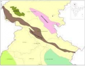
Thus, Karewas are lacustrine deposits (deposits in lake) in the Valley of Kashmir and in Bhadarwah Valley of the Jammu Division. These are the flat topped mounds that border the Kashmir Valley on all sides. They are characterized with fossils of mammals and at places by peat.
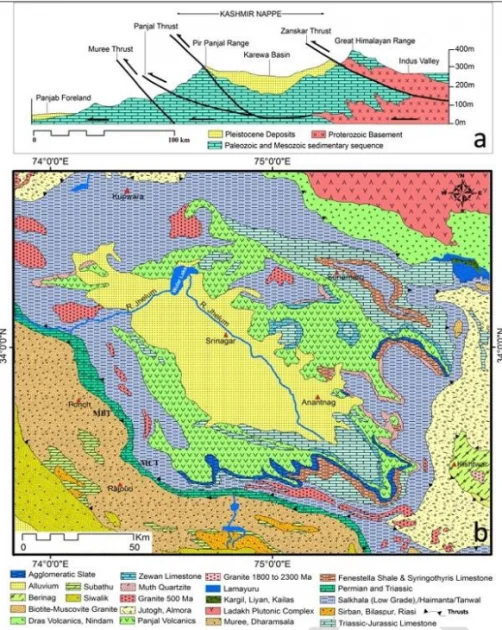
Karewas were formed during the Pleistocene Period (1 million years ago), when the entire Valley of Kashmir was under water. Due to the rise of Pirpanjal, the drainage was impounded and a lake of about 5000 sq. km area was developed and thus a basin was formed. Subsequently, the lake was drained through Bramulla gorge. The deposits left in the process are known as karewas. The thickness of karewas is about 1400 m.
The karewas have been elevated, dissected and removed by subaerial denudation to be in the present position.
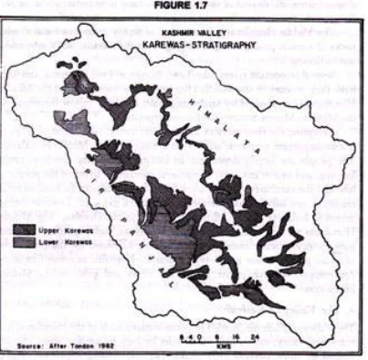
The Karewa deposits in the Kashmir valley have been conventionally divided into two stages, lower and upper, representing argillaceous and arenaceous facies respectively. The upper Karewas are less fossiliferous than the lower Karewas.
35. Prepare an agricultural development plan which will meet twin objectives of productivity and sustainability in Rajasthan region.
Ans. Rajasthan’s climate is marked by frequent droughts, a short monsoon season and extreme temperatures ranging from 5C to 45C and more. Agriculture, which contributes 25 percent of the State GDP, continues to be largely dependent on rainfall, leaving the state highly vulnerable to drought-induced volatility. Rajasthan’s development strategy needs to take into account wide variations in geographical terrain and climatic conditions. Allocating around 80 percent of the state’s water to low value, highly water-demanding crops such as rice and wheat, however, has resulted in a resource use that is economically inefficient and environmentally unsustainable.
A more water-efficient agriculture holds the promise of smallholder farmers profitably shifting from low value, water-guzzling crops to high value farming aiming for returns on unit of water used, and driven by market demand. Other significant opportunities associated with agriculture in Rajasthan include: diversification into higher value, less water consuming horticulture, floriculture, spice and medicinal plant production across a variety of agro- ecological zones; integration with livestock development focusing on improved animal health, nutrition, and access to markets; and roll-out of a range of tested on-farm water management technologies and agronomic practices. Rajasthan is one of India’s largest producers of mustard (oilseed crop), pearl millet (known as bajra), coriander, cumin, and fenugreek, cluster beans, and maize. Rajasthan has the second largest herd of livestock amongst Indian states, contributing about 10 percent of the country’s milk and 30 percent of mutton production.
A sustainable agriculture will be coupled with efficient productivity when complemented by a conducive policy framework that involves water management; improved public sector capacity in delivering agriculture support services; finance and insurance; promotion of linkages; and development of value chains for processing and marketing.
5⦁ Give reasons for skewed level of industrial growth and development as an element of industrialisation with particular reference to emergence of South Indian industrial corridors.
Ans. While India has experienced unprecedentedly high GDP growth rates for the past 15 years, growth seems to have been fuelled from a few sectors of the Indian economy, and only a few states. India’s growth hubs are not connected with each other—either geographically or via a particular engine of growth. With only a handful of growth hubs with no spillover effects, the distribution of employment across the states is highly skewed, leaving pockets of poverty in the poorer states. India’s uneven economic growth therefore threatens to exacerbate regional poverty.
India’s regional development has been particularly uneven and has been polarised, characterised by a high-income club and a low-income club. The rich club constitutes states such as Gujarat, Maharashtra, Punjab and Haryana, with the more recent additions of South Indian states like Tamil Nadu and Karnataka. The low-income club includes Orissa, Bihar, Rajasthan, Madhya Pradesh and Uttar Pradesh, amongst others.
Various reasons attributed to this skewed industrial growth include socio-economic factors varying from the nature of the state to planning and development, fiscal federalism, the tax system, investment, education and infrastructure. Of recent, some South Indian states have entered the rich states’ club—notably Tamil Nadu, on the south-east coast. Tamil Nadu has seen persistent improvement in living standards and today counts as a rich state and is based on manufacturing, particularly ship building. There are, however, no geographical linkages with either Gujarat or Maharashtra. Karnataka in the south-west has also developed an independent growth engine of consulting in finance and information technology for the international market, but demonstrates little connectivity with other regional industries. Thus ha been spurred by the establishment of major industrial corridors like the Bengaluru- Mumbai Economic Corridor (BMEC); Chennai-Bengaluru Industrial Corridor (CBIC); and the Vizag-Chennai Industrial Corridor (VCIC).
The emergence of these industrial regions is attributed to a multitude of factors, such as, ports that facilitate trade, well developed transport and communication with interior regions, climate, mineral resources, potential for hydel
power projects, research and devlopment institutions, and the forward and backward linkages posed by the emerging automobile industry.
DIFFERENTIATE BETWEEN RIVER BASIN AND COMMAND AREA. DISCUSS THE ADVANTAGES AND DISADVANTAGES OF RIVER BASINS AS PLANNING REGIONS IN INDIA. GIVE CONCRETE EXAMPLES.
A⦁ What is CADP?
B⦁ What is River Basin Planning?
C⦁ Differences between command area and River Basins
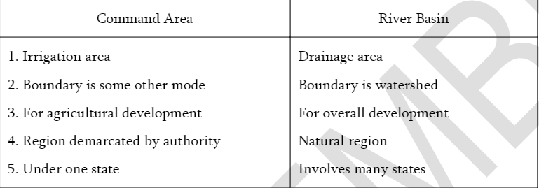
D⦁ Advantages of river basin planning
⦁ Flood control
⦁ Regulation of water flow
⦁ Hydel power development
⦁ Improvement and development of navigation
⦁ Holistic development of the region
⦁ Increasing moisture content and fertility
E⦁ Problems
⦁ Displacement of people
⦁ Not a planning region
⦁ Difficult to collect data
⦁ Political problems related to river water disputes on sharing
⦁ Water logging and Salinisation
⦁ Loss of biodiversity
⦁ RIS
⦁ Permanent flooding
⦁ River basin authority and exactly defined therefore crates administrative problems.
23⦁ Discuss India’s Maritime Threats And Scope Of Expansion With An Emphasis On Indian Ocean.
India’s engagement with the maritime-based globalisation order is an inevitable reality that has powered its economic growth and development to commendable heights. Even as the country grew by impressive growth rates there have been several challenges and pressures that have affected this growth. India’s economic growth and development has several implications in its security and its governance.
The predominant security predicament that India has contended has been the largely land-based symmetrical and asymmetrical threats that it has faced in the northwest with Pakistan and northeast with China.
India’s maritime profile and naval power has come with the UNCLOS III and the Exclusive Economic Zone of 200 km from the shore. The EEZ confers on India its allotted zone of 2,013,410 Sq. km. with huge repositories of mineral wealth, oil and natural gas, living and non-living resources and with its expansive potential by way of extending the continental shelf to almost 2.9 sq. km. equalling the landmass of India.
India’s densely crowded littorals have a higher density of human habitation than the global trend.
Good Governance and social economic development nurtures a vital stake of India’s citizenry the vital synergies as
primary stakeholders in combating crime and terrorism.
A rising India should adeptly balance the imperatives of governance and security on one hand while accentuating growth and stability. There are many challenges to littorals
⦁ India faces a perilous vulnerability of its littoral and the Exclusive Economic Zone fraught with a wide-spectrum of maritime asymmetric as asymmetric threats of increasing incidence of piracy, maritime terrorism, narcotics and light, small arms smuggling – This has been the dense maritime domain of both of native and alien maritime activity with little governance and regulation;
⦁ India’s second maritime – littoral challenge and nightmare is the security of India’s littoral and the security of Sea Lanes of Communication (SLOCs) that abounds the Indian peninsula. Shipping in this domain ranges from fishing trawlers to supertankers and super-container ships. The intense shipping and poaching of foreign trawlers in India’s littorals and the EEZ have wrecked the delicate environmental balance of the diversified and rich marine life and resources of the Arabian Sea-Indian Ocean-Bay of Bengal areas.
⦁ India’s third maritime – littoral challenge and threat is the established nexus between organised crime in the hinterland with terror groups in the proximity of India’s borders and boundaries with Sri Lanka, Myanmar, Bangladesh and importantly from Pakistan (the recent Mumbai terror attacks) have a evidently revealed. The crime syndicates have used the external linkages in the sea-smuggling of narcotics, small arms, explosives to be used in the various criminal are the staging points for the long chain of links in the smuggling process.
⦁ India’s fourth peril in its maritime-littoral corridors is the trafficking of weapons of mass destructions in its components, subassemblies etc. Earlier such merchandise have often been in maritime transit connecting Pakistan from China and North Korea.
⦁ India’s fifth clear and present danger is the daunting weakness in the Maritime domain awareness due to the vast littoral territory and the dense populations in these areas.


