MODEL ANSWERS
Geology has strongly influenced the mineral resource base of India or World.
Explain with examples.
⦁ Meaning of geology
⦁ How geology determines mineral resource distribution
⦁ By age
⦁ By rock formations
⦁ By tectonic activity
⦁ By shield, platform and craton distribution
⦁ By aiding alluvial formation
⦁ By determining the type of mineral deposits
What are the different methods of measuring the heights of mountains and peaks? What are the recent advances made in measuring such heights and elevation.
Before the advent of modern technology, height was measured using three techniques Geodetic method
It’s the oldest known method but one of the most accurate. Early scientific measurements of mountains were made by Greek authors Dicaearchus, Eratosthenes and Xenagoras.
It uses three processes-Levelling, measurement of triangles and determination of distance of a mountain visible at sea.
Method : Similar triangles, usually right triangles, are compared using a hodometer. Other distance measuring instruments include Dioptra, Quadrant, ancient astrolabe, ancient cross-staff and Gnomon.
Barometric method
This is based on the premise that if a mercury column is held up by air pressure, the column is shorter at higher altitudes. Eventually Edmund Haley devised a formula: 0.0144765 H = 900 (log 30-logh), where 30 inches is the height of mercury at sea-level; ‘h’ is its height at the place of observation; and ‘H’ is the elevation. However, the method could never accurately link mountain height to barometric height.
Thermometric Method
This is based on the concept of boiling point of water at different altitudes; the boiling point of water falls with a rise in height.
Henri Victor Rouault constructed an instrument called hypsometer for thermometric measurement. The formula used was: h = 295 (100-t), where h is expressed in metres, t in degrees centigrade.
In 1854, Mount Washington was measured by all 3 methods. It came to 1,917 m by primary triangulation used by the US Coast Survey, to 1,914 m by the process of levelling, 1891.5 m by barometer method, and 1864 m by boiling point method. It was determined that the results given by the barometer, however erratic, wander less from those by the levelling instrument than the other results.
Modern Measurement
Photogrammetry
An alternative method, it is commonly used by the UK to measure its hills and peaks. It involves flying over the area to be measured and taking overlapping, high-resolution photos from which a 3D representation is created. Measurements can then be taken that translate directly to positions and heights in the real world. This method allows large areas to be surveyed quickly and safely and to an accuracy of 3-4m.
GPS
The most accurate method, which Nepal is using for Mount Everest, involves using GNSS (Global Navigation Satellite System). An instant position is determined but the height is not very accurate. For greater accuracy, the GNSS unit has to remain stationary and record data for a period of time.
GPS Second Method
A GPS receiver is planted on top of the mountain. Scientists then time how long it takes for radio signals to travel between the receiver and orbiting satellites. This yields enough data to determine-to within a centimetre- the elevation of the receiver relative to the satellite, which sits at a known distance from the centre of the Earth. But that doesn’t determine the height above sea level. The height of the ocean surface is believed to differ by more than 100 m across the globe. So scientists try to estimate where the sea level would be if the water were lapping up against or indeed flowing through the base of the mountain. The final calculation may not be that precise
Mountains can be measured from different base points
From Sea Level: Measuring elevation from the sea level is one of the most widely accepted techniques. When measuring from sea level, Mount Everest is the uncontested tallest mountain of the world, with a peak that rises 8,848 m above sea level.
From Surrounding Terrain: When measuring Mount Everest, the elevation of the plateau-on which it is situated-from the sea level is also included in the mountain’s height. But if its vertical rise was measured from the surrounding terrain, Everest would lose to Mount McKinley, whose elevation from the sea level is otherwise lower than Mount Everest, but it’s vertical rise is about 5,500 m, compared to Mount Everest’s 3,700 m.
From Its Base: Some measurements are taken from the base of the mountain itself, even if the base is above sea level. Measured in this manner, Mauna Kea, whose base is at the bottom of the Pacific Ocean, is the world’s tallest at 10,203 m. This beats Mount Everest even though Mauna Kea’s elevation is only 4,205 m at its peak.
Mount Lamlam, whose base is deep in the Mariana Trench in the Pacific, is another mountain, which could be tallest when measured from the base. Though reports about its height differ, one report puts its height, when measured from the base, at 11,527 m, making it taller than Mauna Kea.
From Centre Of Earth: When measured from the centre of the Earth, the world’s tallest mountain is Chimborazo, which is 6,384 km at its peak. However, its elevation is only 6,268 m above sea level. It is located in Ecuador, near the equator, which gives it an advantage, because the Earth bulges slightly in the middle.
Discuss the origin of East African Rift Valley? Explain the characteristics of EARV and its uniqueness.
The East African Rift called as EAR is perhaps the most important tectonic feature of Africa.
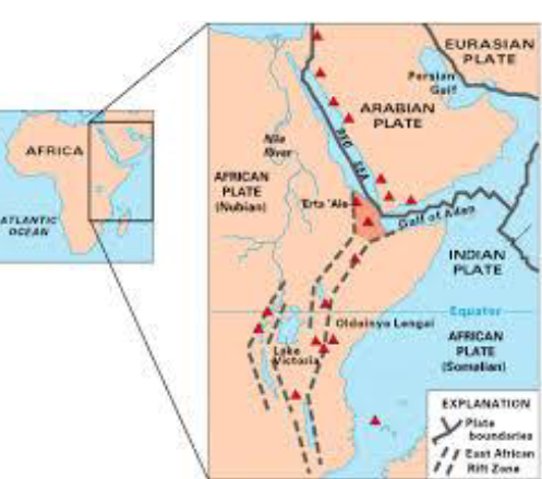
The East African Rift (EAR Valley) is an active continental rift zone in East Africa. The East African Rift Valley begins from Dead Sea to Lake Malawi. In Africa, the northernmost extremity is Lake Assal.
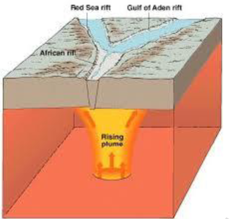
The rift is a narrow crack along which two plates move apart, and along which the African Plate is in the process of splitting into two tectonic plates, called the Somali Plate and the Nubian Plate.
The divergence has led to emergence of a narrow rift valley, which is a normal or step fault extending over thousands of
kilometers.
It is along the EARV that Africa in future is going to be split into two separate continents.
The EAR consists of two main branches
The Eastern Rift Valley includes the Main Ethiopian Rift, running eastward from the Afar and then south as the Kenyan Rift Valley. The East African Rift Valley comprises of the Danakil depression and its volcanoes.
The Western Rift Valley
The Western Rift Valley includes the Albertine Rift, continuing south in the valley of Lake Malawi. There are many crater lakes in the Albertine rift.
The East African Rift Zone includes a number of active as well as dormant volcanoes, among them: Mount Kilimanjaro, Mount Kenya, Mount Nyiragongo, Mount Meru as well as the Crater Highlands in Tanzania. Although most of these mountains lie outside of the rift valley, it was the processs associated with EAR that created them.
Active volcanoes of Africa
Active volcanoes of Africa include Erta Ale, DallaFilla, and Ol Doinyo Lengai. The Erta Ale is the only permanent active volcano. The Ol Doinyo Lengai volcano is the coldest lava eruption in the world and also the only active natrocarbonatite volcano in the world. The magma contains almost no silica, making the flow viscosity extremely low. Its lava fountains crystallize in midair then shatter like glass. Nyirongogo on the Tanzanian-Zaire border is the largest lake filled with lava, hence called a lava lake.
There are good number of boiling water lakes in the African Rift Valley.
The EAR is the largest seismically active rift system on Earth today. It is along the East Africa Rift Valley that Africa is going to be split into two different continents. The majority of earthquakes occur near the Afar Depression, with the largest earthquakes typically occurring along or near major border faults.
The Rift Valley in East Africa has been a rich source of hominid fossils that allow the study of human evolution.
The Rift Valley houses two of the largest national parks in the world-the Serengeti and Masaimara The scene of hunting and be hunted is seen to be believed.
There are many linear lakes that dot the entire of EARV- Lake Assal, Lake Tana, L. Albert, L. Turkana, Lake Edward, etc.
Across the EARV escarpment lies the Victoria falls
Victoria falls over Zambezi river flows in a spectacular gorge. It is a scarp waterfall that falls in the form of a roar, which can be heard from over a kilometer. The Zambezi river cuts a deep wide channel as it flows along the Zambia- Zimbabwe border. The waterfall has an almost permanent rainbow accompanying it.
What is Cosgrove Volcanic Chain and why has it been in news? Discuss its origin and evolution.
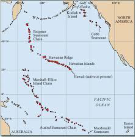
Cosgrove Volcanic Chain is a series of seamounts and guyots created in straight line when a plate passes over a static mantle plume.
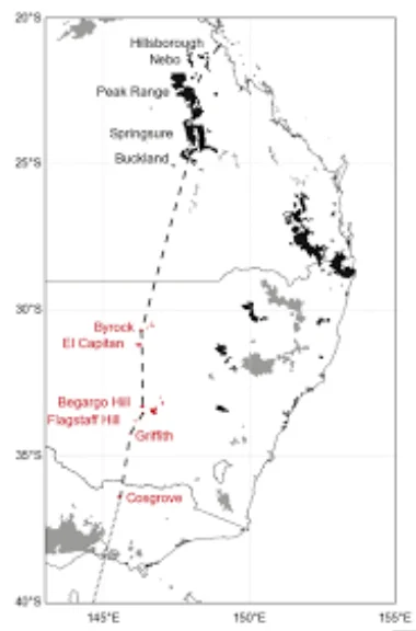
Cosgrove volcanic Chain, is the longest known trail of a hot spot under a continental landmass. Most of the volcanic chains are under water.
These include Emperor Seamount Chain, Austral Marshall Gilbert Chain and Line Tuamotu Chain all in Central Pacific
having a characteristic L shape.
Cosgrove Volcanic chain was in news for having been discovered as early as September 2016 and is the only example of a vocanic chain over land Cosgrove Volcanic Chain was created over the past 33 million years, as Australia moved north-northeast over a mantle plume hotspot which is believed to be now located in Bass Strait.
Australia slowly moved away over this mantle plume and created a 2,000 kilometers long track volcanic activity. Thus Cosgrove volcanic chain is the largest and the only unexplored volcanic chain till now.
The Australian mantle plume is probably still active. Because Australia as it moved further to the north, allowed the mantle plume to located northwest of Tasmania in the sea. This is supported by the elevated jacket temperatures and increased seismic activity. This seismic activity is experienced mostly in Aedelaide closest city to the Chain.


