

1. Consider the following statements:
1. The coastline of India is almost in length half the radius of earth
2. The coastline of India is almost in length of the radius of earth.
3. The coastline of India is almost the same distance as San Francisco to New York.
Which of the above is/are correct
(a) 3 only
(b) 1 only
(c) 2 and 3
(d) 2 only
2. Which of the following statement is/are correct
1. The longitudinal extent of India is almost 30°.
2. The latitudinal extent of India is almost 30°.
3. The N-S extent of Mainland is 3200 km while E-W Extent is 3000 km.
(a) 1 and 3
(b) 2 and 3
(c) 1 and 2
(d) 1, 2 and 3
3. Which of the following relief feature presents a view of senile topography
(a) Nilgiris
(b) Eastern Ghats
(c) Vindhyans
(d) Southern coastal plains.
4. Arrange the following in order of their increasing geological age
1. Ganga plains
2. Himalayas
3. Coastal plains
4. Peninsular plateau
(a) 1-2-3-4
(b) 1-3-2-4
(d) 2-1-3-4
5. Consider the following statements about peninsular plateau
1. The valleys of river in the Peninsular plateau show that they have entered last phase of geomorphic cycle.
2. The rocks have remained free from any horizontal earth movement.
3. The rock at places have undergone vertical uplifts.
4. The peninsular plateau has remained above the sea since Cambrian times
Which of the above is/are correct
(a) 1, 3 and 4
(b) 1 and 4
(c) 1, 2 and 3
(d) All the above
6. Aravalli’s are-
(a) Relict mountains
(b) Relict fault mountains
(c) Relict fold mountains
(d) Fold mountains
7. The great plains of India have remained
(a) Degradational throughout its history
(b) Aggredational throughout its history
(c) Rejuvenated throughout its history
(d) Has entered the last phase of geomorphic cycle
8. Which regional division of Himalayas are longest and shortest respectively?
(a) Nepal Himalayas and Kumaon Himalayas
(b) Punjab Himalayas and Assam Himalayas
(c) Assam Himalayas and Punjab Himalayas
(d) Assam Himalayas and Kumaon Himalayas
9. Match the following devisions of Himalayas with rivers which demarcate their
List I List II
A. Punjab Himalayas 1. Kali to Tista
B. Kumaon Himalayas 2. Sutluj to Kali
C. Assam Himalayas 3. Indus to Sutluj
D. Nepal Himalayas 4. Tista to Dihang
A B C D
(a) 1 2 3 4
(b) 4 3 2 1
(c) 3 2 4 1
(d) 3 4 2 1
10. Match the following longitudinal divisions of Himalayas with their names
List I List II
A. Greater Himalayas 1. Outer
B. Lesser Himalayas 2. Middle
C. Sub Himalayas 3. Inner
A B C
(a) 1 2 3
(b) 3 2 1
(c) 2 1 3
(d) 1 3 2
11. Arrange the following from North to South
1. The Tsangpo valley
2. The Kailash range
3. The greater Himalayas
4. The Laddak range
(a) 1-2-3-4
(b) 1-4-3-2
(c) 3-4-1-2
(d) 2-1-4-3
12. Almost all prominent Himalayan peaks lie in-
(a) Greater Himalayas
(b) Lesser Himalayas
(c) Siwalik Himalayas
(d) Spread over (a), (b) and (c
13. The Aksaichin, Deosai and Depsang plains are-
(a) Old erosional surface
(b) Plains formed due deposition of rivers
(c) Tectonic plains
(d) Highly rugged and hilly
14. The oldest sediments found in Himalayas would belong to
(a) Quaternary period
(b) Tertiary period
(c) Vindhyan times
(d) Archean times
15. Match the following
List I List II
A. Chaj 1. Between Ravi and Chenab
B. Bist 2. Between Chenab and Jhelum
C. Rechna 3. Between Beas and Ravi
D. Bari 4. Between Jhelum Chenab and Indus
E. Sind Sagar 5. Between Beas and Sutluj
A B C D E
(a) 1 2 3 4 5
(b) 5 4 3 2 1
(c) 2 5 1 3 4
(d) 2 1 5 3 4
16. Match the following
List I List II
A. Bhabar 1. Streams which cause gully erosion in foothills of Siwaliks
B. Terai 2. Khadar belt of Punjab
C. Betland 3. Marshy forested area cleared for agriculture in UP
D. Chos 4. A well formed alluvial belt found in UP
A B C D
(a) 4 3 2 1
(b) 4 2 3 1
(c) 4 1 2 3
(d) 2 4 3 1
17. (A): The delta of Narmada is wide
(R): Narmada caries lot of eroded silt along its coarse.
18. (A): Sutluj, Indus and Brahmaputra form gorges
(R): The yare antecedent in nature
19. (A): Metamorphic rocks are abundant in north western Himalayas
(R): Nappies are most common in this region.
20. (A): Eastern Himalayas are higher than their western counter part
(R): Isoclinal and vertical folds are not present in eastern Himalayas.
21. Which of the following statement is correct:
(a) Indian ocean is encircled by 46 countries.
(b) India’s coastline along main land mass is 7100 km.
(c) Total land frontier of India is about 16,000 km.
(d) Southern most point of India is Indira Point which has the latitude of 8°4′ N.
22. Which of the following is not correct about the ‘Bhanger’
(a) It is the older alluvium
(b) It is always above the land of flood plain
(c) It is called ‘BET’ in Punjab.
(d) It is impregnated with calcareous concretions known as Kankar.
23. Which of the following is not correct about the ‘Bhabar’.
(a) It lies along the foot of Siwalik
(b) It comprises of pebble-studded rocks
(c) Most part of the Bhabar area are reclaimed for agriculture.
(d) Due to porosity of the rocks, the streams disappear and flow underground.
24. Bagar-which contains salt soaked playa lakes is locally known as
(a) Rohi
(b) Sar
(c) Bhils
(d) Dhrian
25. The ancient Vindhyan sediments through which Chambal river has cut deep and wide valley is popularly known as
(a) Chos
(b) Ravines
(c) Bhils
(d) Dhaya
26. Which of the following is not correct about Western Ghats
(a) The average elevation is 900-1100 m
(b) The average width is 50 to 80 km
(c) The structural unit is lacking
(d) Stands like a continuous wall and can be crossed through passes only
27. Arrange the following in descending order of their heights, and mark which is the correct one:
1. Kanchunjunga
2. Annapurna
3. Nanda Devi
4. Kamet
(a) 1, 2, 3, 4
(b) 1, 2, 4, 3
(c) 2, 1, 3, 4
(d) 2, 1, 4, 3
28. Which of the following is not correct about East coastal plain.
(a) Located between the eastern Ghats and Bay of Bengal coast
(b) The average width is 80-100 km
(c) The eastern plain has more or less a straight coast where good ports are lacking.
(d) It is submerged coast.
29. Which of the following is not correct about the Himalayan Rivers:
(a) They are perennial in nature
(b) They have uncertain nature and are shifting in behaviour.
(c) The rivers are in old stage
(d) Rivers are eroding, transporting and depositing agents.
30. Which of the following is not correct about the East flowing rivers:
(a) Their catchment area is wide and fan shaped.
(b) They form deltas and have deltaic deposits.
(c) Many waterfalls are found on these rivers.
(d) They carry much more sediments than the west flowing rivers.
31. “The river Rises in Dandkarnaya, Sihawa range and Southern part of Chattisgarh plain, it receives Sheonath river on its left bank”, The above ‘description is of which river.
(a) Narmada
(b) Mahanadi
(c) Tapti
(d) Damodar
32. The Shivasamudram fall is on which of the following rivers.
(a) Cauvery
(b) Subarnarekha
(c) Tons
(d) Sharavati
33. Which of the following is the Asia’s largest brackish water lake
(a) Sambhar
(b) Wular
(c) Jaisamand
(d) Chilka
34. Which of the following is not correctly matched
(a) Loktak lake- Manipur.
(b) Panchbhadra lake-Rajasthan
(c) Tso Murari lake – Himachal Pradesh
(d) Asthamudi lake – Kerala
35. Which of the following states has the largest Number of the tube-wells in the country
(a) Punjab
(b) UP
(c) Haryana
(d) Maharashtra
36. Which of the following states have the largest percentage of irrigation through the canals.
(a) J & K
(b) Assam
(c) Haryana
(d) Orissa
37. Which of the following states have the largest forest cover among the following states,
(a) Orissa
(b) Maharashtra
(c) Andhra Pradesh
(d) Karnataka
38. Which of the following Biosphere Reserves is not correctly matched?
(a) Nokrek – Meghalaya
(b) Simplipal-Orissa
(c) Dibru Daikhowa – Arunachal Pradesh
(d) Agasthyamalai – Kerala
39. Which of the following is not recognised on world Network of Biosphere Reserve by UNESCO-
(a) Nilgiris
(b) Manas
(c) Sunderban
(d) Gulf of Mannar
40. Which of the following wetlands is not correct matched
(a) Nalsarovar-Gujrat
(b) Ujni-Maharashtra
(c) Kabar-Jharkhand
(d) Sukhna-Chandigarh
41. Which of the following is the typical example of Atoll reefs
(a) Gulf of Kuchch
(b) Lakshdweep Islands
(c) Gulf of Mannar
(d) A & N Islands
42. Which of the following bird sanctuary is not correctly matched.
(a) Ghatprabha – Karnataka
(b) Great Indian Bustard – Rajasthan
(c) Kolleur- Andhra Pradesh
(d) Pakhiralaya – W. Bengal
43. Which of the following National Parks is not correctly matched.
(a) Valley of Flowers – Uttaranchal
(b) Bandipur – Karnataka
(c) Balphakaran – Meghalaya
(d) Sirohi – Arunachal Pradesh
44. Which of the following wild life sanctuaries is not situated in the Tamil Nadu
(a) Mudumalai
(b) Pakhal
(c) Kalakad
(d) Mandanthurai
45. Which of the following is not correct statement:
(a) Kaziranga in Assam is famous for one horn Rhinocerous
(b) Periyar in Kerala in famous for Elephants.
(c) Asiatic lions are found in Gir forests.
(d) Rajasthan is also known as the Tiger State.
46. Which of the following is not correctly matched:
(a) Project tiger – 1973
(b) Rhinocerous project – 1975
(c) Project Elephant – 1988
(d) Crocodile Breeding project – 1975
47. Which of the following states have highest and lowest densities of Road respectively.
(a) Kerala arid Jammu and Kashmir
(b) Goa and Jammu and Kashmir
(c) Maharashtra and Himachal Pradesh
(d) Goa and Himachal Pradesh
48. Arrange the following states in descending order of total length of roads situated in them.
1. Orissa
2. Maharashtra
3. Uttar Pradesh
4. MP
(a) 1,2, 3, 4
(b) 2, 1, 4, 3
(c) 1, 2, 4, 3
(d) 2, 1, 3, 4
49. Which of the following National Highways passes through the Rajasthan Desert
(a) NH-3
(b) NH-7
(c) NH-15
(d) NH-20
50. Arrange the following states in the ascending order of the National Waterways in length.
1. Assam
2. West Bengal
3. Andhra Pradesh
4. Uttar Pradesh
(a) 1, 2,3, 4
(b) 1, 2, 4, 3
(c) 1,3, 2, 4
(d) 1, 3, 4, 2
51. Which of the following statements is/are correct
(a) One third of the total population of Christians live in Kerala.
(b) Nagaland has the highest percentage of Christian Population
(c) HP and Rajasthan have the smallest percentages of Christian Population.
(d) All of the above
52. Arrange the following North-East states in descending order of Density of population
1. Tripura
2. Nagaland
3. Assam
4. Meghalaya
(a) 1,2, 3, 4
(b) 3, 1, 2, 4
(c) 1, 2, 4, 3
(d) 3,1, 4, 2
53. Which of the following states is below the National Average of literacy (65.38%)
(a) Tamil Nadu
(b) Chattisgarh
(c) Harayana
(d) Karnataka
54. Which of the following is the largest centre for wave energy in India
(a) Gulf of Khambhat
(b) Gulf of Kuchch
(c) Vizinjam, Kerala
(d) Andaman and Nicobar
55. Which of the following states is the highest producer for both thermal and hydroelectric production combined,
(a) UP
(b) Maharashtra
(c) Gujrat
(d) Tamil Nadu
56. Arrange the following as percentage Area of crops under irrigation in descending order,
1. Barley
2. Rice
3. Maize
4. Wheat
(a) 4, 3, 2, 1
(b) 4, 1, 2, 3
(c) 4, 2, 3, 1
(d) 4, 2, 1, 3
57. Arrange the following countries in increasing order of their population density
1. India
2. China
3. Bangladesh
4. Japan
(a) 1, 2, 3, 4
(b) 2, 3, 4, 1
(c) 2,1, 4, 3
(d) 1, 2, 3, 4
58. Village and town confined between two rivers at their confluence which type of settlement pattern results?
(a) Checkerboard pattern
(b) Star shaped pattern
(c) Fan shaped pattern
(d) Arrowhead pattern
59. Which of the following pair is not correct matched:
(a) Marble: Limestone
(b) Quartzite: Sandstone
(c) Gneiss: Shale
(d) Schist: Basalt
60. The main watershed of Peninsular India is formed in
(a) Western ghat
(b) Eastern ghat
(c) Satpura ghat
(d) Ajanta range
Directions:
61. (A): Northern India has an extra tropical location but a tropical climate.
(R): Himalayas insulate the climate of the country from influence of cold winds.
62. (A): The vegetation of India is diverse in nature
(R): Besides climate altitude plays a great role in vegetational type.
63. (A): The forest in eastern Himalayas begin at a greater height than in western Himalayas.
(R): Eastern Himalayas are almost 7° closer to equator.
64. (A): Himalayas are perfect water divide.
(R): Many rivers originate and flow south wards from Himalayas.
65. (A): The area under Dry deciduous vegetation has encroached upon area of moist deciduous forest.
(R): Overgrazing and poor maintenance are degenerating forces.
66. (A): Western disturbance cause rainfall in winter in the northwest part of India.
(R): The westerlies shift equator ward during winter in Northern Hemisphere.
67. (A): Tank irrigation is particularly important in peninsular plateau.
(R): Peninsular plateau with highly dissected step like topography has many depressions.
68. (A): The climate of Bangalore is not extreme.
(R): Bangalore is situated at a height of 909 m from the sea level.
69. (A): The peninsular plateau has dissected step like topography.
(R): Hydel power is a major source of energy.
70. Which factors influence the density and distribution of population in India the most?
1. Amount of Rainfall
2. distribution of minerals
3. fertility of soils
4. cultural factors
(a) 1 and 2
(b) 2 and 3
(c) 3 and 4
(d) 1 and 3
71. Which in an area of dispersed settlements in India?
(a) Punjab
(b) Rajasthan
(c) Maharastra
(d) Himachal Pradesh
72. The Gold deposits of India occur in
(a) Tertiary rocks
(b) Gondwana rocks
(c) Cuddapah rock
(d) Dharwar rocks
73. _____________________was the first Nuclear reactor of India
(a) Zerlina
(b) Dhruva
(c) Apsara
(d) Fast breeder
74. Lake Lonar is situated in which of the following states
(a) Gujarat
(b) Tamil Nadu
(c) Kerala
(d) Maharashtra
75. Narmada valley is
(a) Glacial in origin
(b) Volcanic in origin
(c) Structural in origin
(d) Wind eroded valley
76. The Sugarcane plantations have shifted from Northern plains towards southern India due to
1. Overseas trade in sugar
2. Higher prices for sugar
3. Water retentive volcanic soils
4. Better management of sugar industries.
(a) 1, 2 and 3
(b) 2, 3 and 4
(c) 3 and 4
(d) 1 and 2
77. Ratanpir, Pir Panjal and Dhauladhar are ranges belonging to-
(a) Inner Himalayas
(b) Lesser Himalayas
(c) Shayadris
(d) Purvanchal Hills.
78. Which of the following substance are found in the beach sands of Kerala.
1. Illimenite
2. Zircounium
3. Monazite
4. Tungsten
Select the correct answer using the code given below
(a) 1,2 & 3
(b) 3 & 4
(c) 1 , 2 & 4
(d) All the above
79. Adam’s Bridge is located between.
(a) Thalai mannar and pamban Island
(b) Point pedro and point calimere
(c) Dhanuskodi and Rameshwaram
(d) Point calimere and Triconamale
80. Consider the following statements.
1. Gujarat coast is the highest tidal power potential coast
2. Gujarat is important producer of wind power.
3.Highest number of major ports located are in Tamil Nadu.
of the above, which of the following is correct.
(a) 1 & 2
(b) 2 & 3
(c) 1& 3
(d) All the above
81. Match list I and List II and select the correct code given below.
List I List II
A. Kayatthar 1. Asia’s largest cluster of wind mill
B. Mahendragiri 2. Single largest wind mill
C. Lamba 3. Liquid propulsion systems centre
D. Satara 4. Wind mill
A B C D
(a) 3 1 4 2
(b) 1 3 2 4
(c) 1 3 4 2
(d) 3 1 2 4
82. Consider the following statements :
1. Silent valley national is park located in Kerala.
2. Biodiversity of silent valley is equivalent to equatorial rain forest.
3. Shola forest in India are located at Silent valley.
4. Pathrak kadavu hydroelectric project is proposed to the built near the silent valley National Park.
Of the above, correct ones are
(a) 1,2, 3
(b) 1,3, 4
(c) 2,3, 4
(d) All the above.
83. Which on of the following pairs of cities are known as twin cities in India?
(a) Ahmendabad – Vadodara
(b) Delhi – Gurgaon.
(c) Bomay – Thane
(d) Hyderabad – Secunderabad
84. Why is talcher famous for ?
(a) Heavy water plant
(b) Coal mines.
(c) Thermal Power
(d) All the above
85. The richest reserves of natural gas found in India is
(a) Krishan- Godavari Basin
(b) Jayam Kondam of Tamil Nadu
(c) Mumbai High
(d) Brahmaputra valley
86. Match List I and List II and select the correct code given below.
List I (Site) List II (Mineral)
A . Jayam Kondam 1. mineral oil
B. Kalakot 2. Bauxite
C. Digboi 3. Lignite
D. Ratnagiri 4. Anthracite coal
A B C D
(a) 1 2 3 4
(b) 1 4 3 2
(c) 3 2 1 4
(d) 3 4 1 2
87. Which on of the following National Highway routes is the longest.
(a) Agra – Mumbai
(b) Kolkata – Hajira
(c) Chennai – Thane
(d) Chennai – Baharagora
88. Match List I and List II and select the correct code given below.
List I List II
(Thermal Power) (State)
A. Obra 1. Gujarat
B. Ramagundam 2. Uttar pradesh
C. Chandrapur 3. Andhra Pradesh
D. Dhuvaram 4. Maharastra
A B C D
(a) 2 3 4 1
(b) 2 1 4 3
(c) 4 1 2 3
(d) 4 3 2 1
89. Consider the following statements.
1. Nearly 90 % of the potential fishing grounds of India confined is within 200m depth.
2. More than ¾ th of total marine fish production comes from west coast.
3. More than half of total fish production is obtained from inland fisheries.
4. Cochin is an important centre of shrimp culture. (a) 1, 2 & 3
(b) 1, 3 & 4
(c) 2, 3 & 4
(d) All the above
90. Match List I and List II and select the correct code given below.
List I (Minerals) List II
A. Coal 1. Dharwar
B. Copper 2. Udaipur
C. Manganese 3. Neyveli
D. Zinc 4. Balghat
A B C D
(a) 1 4 3 2
(b) 3 4 1 2
(c) 1 2 3 4
(d) 3 2 1 4
91. Which one of the following is highest hydel power potential region in India.
(a) East flowing rivers.
(b) West flowing rivers.
(c) North eastern states.
(d) Northern states.
92. Which one of the following rock formations in India is having coal resources ?
(a) Gondwana rock
(b) Dharwarian rock
(c) vindhyan rock
(d) cuddapah rock
93. The only joint sector oil refinery in India is (a) Mangalore
(b) Chennai
(c) Haldia
(d) Trombay
94. Consider the following statements
1. Jaduguda mines in Jharkhand famous for its uranium deposits.
2. Tertiary coal in India obtained from North eastern states.
3. Mumbai high is the leading producer of oil in India.
4. ‘Thal’ in Maharastra is important heavy water plant in India.
Of the above
(a) 1, 2, 3
(b) 2, 3 & 4
(c) 1, 3 & 4
(d) All the above
95. Match List I and List II and select the correct code given below.
List I List II
A. Pimpri 1. Tanks
B. Vizag 2. Penicillin
C. Chittaranjan 3. Steel
D. Avadi 4. Locomotives
A B C D
(a) 4 1 2 3
(b) 2 3 4 1
(c) 2 1 4 3
(d) 4 3 2 1
96. Match List I (Crop) and List II conditions for growth and select the correct code from below.
List I (Crop) List II (Conditions for growth)
A. Wheat 1. Temperature – 210-300C, Average rain fall – 50-100 cm & 210 frost free days.
B. Cotton 2. Temperature -150C-260C, Average rainfall – 75 cm, loamy soil
C. Maize 3. Temperature – 210C 270C, Average rainfall 50-100 cm 135 days frost free.
D. Jute 4. Temperature- 240C-350C, Average rainfall – 120 – 150 cm
well drained sandy and clayey
loam.
A B C D
(a) 1 2 4 3
(b) 2 1 3 4
(c) 1 2 3 4
(d) 2 1 4 3
97. Which one of the following is the correct sequence in terms of decreasing order of the population of given cities.
1. Kolkata
2. Ahmedabad
3. Hyderabad
4. Chennai
5. Bangalore
(a) 1, 4, 5,. 2 ,3
(b) 1, 5, 4, , 3
(c) 1, 4, 5, 3, 2
(d) 1, 5 , 4, 3, 2
98. Consider the following statements :
1. Total urban population in India increased eleven fold since 1901
2. Urban centre with population of more than one lakh is called a city and less than one lakh is called town.
3. Kolkata is the largest urban populated cities in India
4. One fourth of urban population lives in middle sized towns of India.
Which of the above is/are correct
(a) 1, 2, 3
(b) 3 & 4
(c) 1, 2 & 4
(d) All the above
99. Which one of the following facts is incorrect with reference to census definition of urban centres in India.
(a) Literacy rate of female must be more than 75%
(b) A minimum population of 5000 persons
(c) At least 75 percent of male working population engaged in non-agricultural pursuits.
(d) A density of population of at least 400 persons per sq. km.
101. Match List I (District) and List II (Population attributes) and select the correct code given below.
List I (District ) List II (Population)
A. Dhaulpur (Rajastan) 1. The highest density
B. Lahul and spiti (H.P.) 2. Moderate density
C. North East Delhi 3. The least density
D. Rayalaseema 4. National Average density
A B C D
(a) 4 3 1 2
(b) 4 1 3 2
(c) 2 1 3 4
(d) 2 3 1 4
102. Mark the incorrect pair.
(a) 1921 – demographic divide
(b) Before 1921 – declining growth of population
(c) 1921 – 1951 – steady growth rate of population
(d) 1951 – 1981 – rapid growth rate of population
103. Match List I (Stages) and List II (description) and select the correct code given below.
List I (Stages) List II (description of demographic transition)
A. Stage I 1. High death and birth rate low growth rate.
B. Stage II 2. Rapid decline in death rate high birth rate and hence very high growth rate.
C. Stage III 3. Rapid decline in birth rate decline in death rate and decline in growth rate.
D. Stage IV 4. Low death and birth rates and low growth rate.
A B C D
(a) 1 2 4 3
(b) 2 1 3 4
(c) 1 2 3 4
(d) 2 1 4 3
104. Consider the following statements.
1. The highest growth rate of population is recorded in Nagaland in India.
2. Kerala recorded lowest growth rate of population among all the state’s
3. The birth rate is comparatively lower in all Southern States.
4. North eastern states recorded high growth rate among all state in India.
Of the above which of the following is correct. (a) 1, 2, 3
(b) 1, 3 & 4
(c) 2, 3 & 4
(d) All the above.
105. Consider the following statements.
1. India is leading producer of sheet mica in the world.
2. India is the leading producer of sugarcane.
3. Peninsular India is the most suitable for wells and tube wells.
4. Tank irrigation is predominant mode of irrigation in Northern plain.
Of the above, correct ones are
(a) 1 & 2
(b) 3 & 4
(c) 2 & 3
(d) All the above
106. Match List I and List II and select the correct code given below.
List I List II
(Places) (Industry)
A. Kanpur 1. Heavy water plant
B. Titagarh 2. Fertilizer
C. Neyveli 3. Jute textile
D. Vadodara 4. Woollen textile
A B C D
(a) 3 4 2 1
(b) 4 3 1 2
(c) 4 3 2 1
(d) 3 4 1 2
107. Consider the following statements.
1. Sugar production in peninsular plateau is the highest in India.
2. Than higher sucrose content present in the sugarcane which was grown in Northern plain.
3. The highest productivity of sugarcane is recorded in Tamil Nadu.
Correct ones are.
(a) 1 & 2
(b) 2 & 3
(c) 1 & 2
(d) All the above.
108. Match List I with List II and select the correct code given below.
List I List II
A. Mamit 1. The largest proportion of working population.
B. Dadra nad 2. The largest population
Nagar Haveli
C. Aizwal 3. The least growth rate.
D. Mednipur 4. The highest literacy rate.
A B C D
(a) 3 1 4 2
(b) 3 2 4 1
(c) 4 2 3 1
(d) 4 1 3 2
109. Match List I with List II and select the correct code given below.
List I (State) List II (Population attribute)
A. Pondicherry 1. The most urbanised
B. Dadra and 2. Sex ratio above parity. Nagar Haveli
C. Daman and Diu 3. Highest urban growth
D. Goa 4. The lowest Sex ratio.
A B C D
(a) 2 3 1 4
(b) 3 2 1 4
(c) 3 2 4 1
(d) 2 3 4 1
110. Which one of the following is the correct sequence in decreasing order of the population in terms of language spoken in India.
1. Bengali
2. Marathi
3. Telegu
4. Tamil
5. Urdu
(a) 1, 2, 3, 5, 4
(b) 1, 2, 3, 4, 5
(c) 1, 3, 2, 4, 5
(d) 1, 3, 2, 5, 4
111. Which one of the following statement is not correct.
(a) Mineral resource found in Aliabet Island of Gujarat is mineral oil.
(b) Magnesite, Kyanite and Sillimanite are refractory mineral available in India.
(c) Limonite and Monazite are ores of Thorium.
(d) India is one of the leading producer of uranium in the world.
112. Match List I (Tribals) with List II (Region) and select the correct code given below.
List II (Tribals) List II (Region)
A. Minas 1. Maharastra
B. Gujjars 2. Andhra Pradesh.
C. Warlis 3. Jammu and Kashmir
D. Chenchus 4. Rajasthan
A B C D
(a) 4 2 1 3
(b) 4 3 1 2
(c) 1 3 4 2
(d) 1 2 4 3
113. Which one of the following statements is incorrect.
(a) The highest number of Muslim population is found in Jammu and Kashmir.
(b) The largest number of Muslim population found in Uttar Pradesh.
(c) The largest number of Christian populated state is Mizoram.
(d) Largest number as well as largest proportion of Sikhs are found in Punjab.
114. Match List I (Minerals) with List II (Utility) and select the correct code given below.
List I (Minerals) List II (Utility)
A. Manganese 1. Refractory
B. Mica 2. Steel alloy
C. Gypsum 3. Cement
D. Sillimanite 4. Electrical equipment.
A B C D
(a) 2 4 3 1
(b) 3 4 2 1
(c) 3 1 2 4
(d) 2 1 3 4
115. Match List I (Soils) and List II (Region) and select the correct code given below.
List I List II
(Soils) (Region)
A. High lands 1. Red Soil
in Peninsula
B. Periphery of 2. Lava Sol
peninsular plateau
C. River basin and 3. Lateritic
coastal plains
D. Maharastra plateau 4. Alluvial
A B C D
(a) 1 3 2 4
(b) 3 1 2 4
(c) 3 1 4 2
(d) 1 3 4 2
116. Which one of the following statement is incorrect.
(a) Tides are of great help in navigation and fishing.
(b) Kandla and Kolkata are riverine ports in India.
(c) Vishaka patinam is the deepest port in India.
(d) Kandla is the largest port in terms of trade.
117. Rawa offshore block with great potential of oil is located on.
(a) Andhra coast
(b) Tamil Nadu coast
(c) Utkal Plain
(d) Kerala coast
118. Match List I with List II and select the correct answer given below.
List I (Industry) List II (Centre)
A. Pearl fishing 1. Kalamassery
B. Diamond cutting 2. Koyali
C. Oil refining 3. Tuticorin
D. Machine tools 4. Surat
A B C D
(a) 3 4 1 2
(b) 3 4 2 1
(c) 4 3 2 1
(d) 4 3 1 2
119. Which one of the following steel plant is the first integrated steel plant in India.
(a) IISCO
(b) TISCO
(c) Vzjag steel plant
(d) Bhadravati steel plant.
120. The first steel plant which is based on charcoal.
(a) Vijay Nagar
(b) Bhilai
(c) Bokaro
(d) Bhadravati
121. Which one of the following statements is not correct.
(a) HSL, Salem produces stain less steel.
(b) Visweswaraya steel plant produces high quality chrome steel.
(c) Vizag is the first shore based steel plant.
(d) Bokaro steel plant is located on the river bank of Sakehi.
122. Match List I and List II and select the correct code given below.
List (Aluminium) List II (Location)
A. BALCO 1. Koraput
B. MALCO 2. Korba
C. HINDALCO 3. Mettur.
D. NALCO 4. Renukoot
A B C D
(a) 2 4 3 1
(b) 2 3 4 1
(c) 1 3 4 2
(d) 1 4 3 2
123. Which one of the following is the incorrect pair with reference to head quarters and Railway zone in India,
(a) South Central : Chennai
(b) North Central : Allahabad
(c) North Eastern Frontier : Maligaon
(d) East Central : Hajipur
124. North-South corridor project of National Highway development programme connects.
(a) Kanya Kumari and Srinagar.
(b) Porbandar and Silcher
(c) Jammu Tawi and Chennai
(d) Jammu and Chennai
125. Match List I and List II and select the correct code given below.
List I (Shipyard) List II (Activities)
A. Cochin 1. Construction of Naval Strips
B. Goa 2. The project seabird
C. Mazagon docks 3. Finest shipyard; construction of fibreglass boats.
D. Kanwar 4. The largest shipyard
A B C D
(a) 3 4 1 2
(b) 4 3 1 2
(c) 4 3 2 1
(d) 3 4 2 1
126. Which one of the following is not oil refinery in India.
(a) Bongaigaon.
(b) Barauni
(c) Tuticorin
(d) Tatipaka
127. Match List I (Port) with List II (Significance) and select the correct code given below.
List I List II
(Port) (Significance)
A. Navasheva 1. Largest port in terms of volume (JNPT) of cargo handled.
B. Mumbai 2. Highly mechanised port.
C. Ennore 3. Iron ore exporting port
D. Vizag 4. first corporatised port
A B C D
(a) 4 3 2 1
(b) 2 1 4 3
(c) 4 1 2 3
(d) 2 3 4 1
128. Which one of the following is the gas pipeline in India.
(a) HBJ pipeline
(b) Salaya – Mathura pipeline
(c) Mumbai High – Trombay
(d) Digboi – Barauni pipeline
129. Match List I and List II and select the correct code given below.
List I (Industry ) List II (Location )
A. Leather 1. Kapurthala
B. Aircraft 2. Murshidabad
C. Rail coach 3. Kanpur
D. Silk 4. Chennai
A B C D
(a) 1 2 3 4
(d) 3 4 1 2
(c) 3 2 1 4
(d) 1 4 3 2
130. Which one of the following gaps in western ghats is the correct order from north to south.
1. Thalghat
2. Palghat
3. Shencottah
4. Borgaht
(a) 1, 4, 2, 3
(b) 1, 4, 2, 3
(c) 4, 1, 3, 2
(d) 1, 4, 3, 2
131. Which one of the following State/UT has the maximum forest cover as a percentage of its total area
(a) Arunachal Pradesh
(b) Jammu and Kashmir
(c) Andaman and Nicobar Islands
(d) Madhya Pradesh
132. Match List I and List II and select the correct code given below.
List I (State) List II(Population attribute)
A. Madhya Pradesh 1. Maximum proportion of S.C population
B. Mizoram 2. Highest proportion of S.T population
C. Uttar Pradesh 3. Highest number of S.C population
D. Punjab 4. Highest proportion of S.T population
A B C D
(a) 2 4 1 3
(b) 2 4 3 1
(c) 4 2 1 3
(d) 4 2 3 1
133. Which of the following is an example of ox-bow lake-
(a) Nainital
(b) Sambhar
(c) Chilka
(d)Wular
134. Dehradun and Gulmarg are formed of
(a) Glacial deposits
(b) Fluvial deposits
(c) Marine deposits
(d) Lacustuarine deposits
135. Kolkata shares the same latitude with which of the following cities.
1. Mandalay (Myanmar)
2. Muscat (Oman)
3. Guangzhou (China)
4. Hanoi (Vietnam)
(a) 1, 2 and 3
(b) 1, 3 and 4
(c) 2 and 3
(d) All the above
136. Arrange the following cities from North to South 1. Nagpur
2. Pune
3. Hyderabad
4. Mumbai
(a) 1-4-2-3
(b) 4-2-1-3
(c) 2-1-3-4
(d) 3-4-1-2
137. Tropic of cancer passes through which of the following states.
1. Bihar
2. West Bengal
3. Gujarat
4. Maharastra
5. Rajasthan
6. Mizoram
7. Tripura
8. MP
(a) 2, 3, 5, 6, 7, 8
(b) 5, 6, 1, 2, 3, 8
(c) 2, 3, 4, 5, 6, 7
(d) 1, 2, 3, 6, 7, 8
138. Arrange the following from North to South.
1. Little Andaman
2. South Andaman
3. Car Nicobar
4. Little Nicobar
(a) 1-2-3-4
(b) 2-3-1-4
(c) 2-1-3-4
(d) 1-2-4-3
139. Arrange the following territories of Pondichery from East west in clockwise direction
1. Karaikal
2. Mahe
3. Yanam
4. Puduchcheri
(a) 3-4-1-2
(b) 2-3-4-1
(c) 1-3-2-4
(d) 4-1-2-3
140. 10° Channel separates
(a) South Andaman and Little Andaman
(b) Little Andaman and Car Nicobar
(c) Lakshwadeep with Maldives
(d) Nancowry island and Little Nicobar
141. Indira Point, southernmost point of the county is located in
(a) Car Nicobar
(b) Little Nicobar
(c) Great Nicobar
(d) South Andaman
142. Capital of Lakshwadeep is
(a) Kavarathi
(b) Minicoy
(c) Amindivi
(d) Agatti
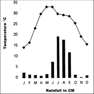
143. The following climograph belongs to which station
(a) Bangalore (b) Kolkata (c) Mumbai (d) Delhi
144. The shaded areas represents-

(a) Sugarcane growing areas
(b) Cotton growing areas
(c) Rice growing areas
(d) Pulse growing areas
145. The shaded areas represents-
(a) Cotton growing areas
(b) Areas of ship farming
(c) Areas of stepped vegetation
(d) Areas of black cotton soil
146. The following data represents the temperature and rainfall data of a station. The station is
| J | F | M | A | M | J | J | A | S | O | N | D | |
| T(°C) | 24.4 | 24.4 | 26.7 | 28.3 | 30.0 | 28.9 | 27.2 | 27.2 | 27.2 | 27.8 | 27.2 | 25.0 |
| RF (cm) | 0.2 | 0.2 | – | – | 1.8 | 50.6 | 61.0 | 36.9 | 26.9 | 4.8 | 1.0 | – |
(a) Delhi (b) Mumbai
(c) Kolkata (d) Chennai
147. The following data represents the temperature and rainfall data of a station. The station is
| J | F | M | A | M | J | J | A | S | O | N | D | |
| T(°C) | 19.6 | 22.0 | 27.1 | 30.1 | 30.4 | 29.9 | 28.9 | 28.7 | 28.9 | 27.6 | 23.4 | 19.7 |
| RF (cm) | 1.2 | 2.8 | 3.4 | 5.1 | 13.4 | 29.0 | 33.1 | 33.4 | 25.3 | 12.7 | 2.7 | 0.4 |
(a) Delhi (b) Mumbai
(c) Kolkata (d) Chennai
148. The following data represents the temperature and rainfall data of a station. The station is
| J | F | M | A | M | J | J | A | S | O | N | D | |
| T(°C) | 16.8 | 19.2 | 26.6 | 29.8 | 33.3 | 33.9 | 31.3 | 29.0 | 20.1 | 27.0 | 20.1 | 14.9 |
| RF (cm) | 0.5 | 0.6 | 0.3 | 0.3 | 1.0 | 3.1 | 10.8 | 13.1 | 5.7 | 0.8 | 0.2 | 0.2 |
(a) Nagpur
(b) Shillong
(c) Jodhpur
(d) Leh
149. The following data represents the temperature and rainfall data of a station. The station is
| J | F | M | A | M | J | J | A | S | O | N | D | |
| T(°C) | 26.7 | 27.3 | 28.3 | 28.7 | 28.6 | 26.6 | 26.2 | 26.2 | 26.5 | 26.7 | 26.6 | 26.5 |
| RF (cm) | 2.3 | 2.1 | 3.7 | 10.6 | 20.8 | 35.6 | 22.3 | 14.6 | 13.8 | 27.3 | 20.6 | 7.5 |
(a) Bangalore
(b) Shilong
(c) Thiruvananthapuram
(d) Leh
150. The following data represents the temperature and rainfall data of a station. The station is
| J | F | M | A | M | J | J | A | S | O | N | D | |
| T(°C) | -8.5 | -7.2 | -0.6 | 6.1 | 10.0 | 14.4 | 17.2 | 16.1 | 12.2 | 6.1 | 0.0 | -5.6 |
| RF (cm) | 1.0 | 0.8 | 0.8 | 0.5 | 0.5 | 0.5 | 1.3 | 1.3 | 0.8 | 0.5 | – | 0.5 |
(a) Leh
(b) Thiruvananthapuram
(c) Bangalore
(d) Shilong
