


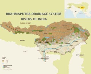
Brahmaputra Drainage System Brahmaputra sub-basin extends over an area of 580,000 sq. km. lying in Tibet (China), Bhutan, India and Bangladesh. The drainage area lying in India is 194413 sq. km. which is nearly 5.9% of the total geographical area of the country.
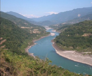
The Brahmaputra originates from Chemayungdung Glacier located near Manasarowar Lake. It then flows in the north of Himalayas in a directin parallel to it. It is known as Tsang Po in Tibet. It takes a southward turn near Namcha Barwa and enters Arunachal Pradesh as Dihang River. Thereafter, it flows in a westerly direction upto Dhubri, near Indo-Bangladesh border. After this, it takes a southern turn and enters Bangladesh as the Jamuna.
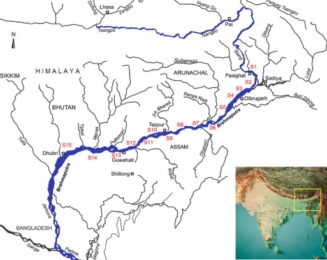
The samples were collected in pre-monsoon period using grab sampling method from fifteen locations of Arunachal Pradesh and Assam, i.e., Pasighat (S1), Guijan (S2), Raumeria (S3), Dibrugarh (S4), Dikhomukh (S5), Nimatighat (S6) Dhansirighat (S7), Kaziranga (S8), Silghat (S9), Laharighat (S10), Gagalmari (S11), Hatisila (S12), Pandu (S13), Jogighopa (S14) and Dhubri (S15) of the Brahmaputra River from upstream to downstream.
Also Read : Indian Drainage System
It flows southwards to meet the Ganga which is known as the Padma in Bangladesh. Several tributaries join the Brahmaputra. Important right bank tributaries are Subansiri and Menas while important left-bank tributaries are Dibang, Luhit and Dhansiri. Because of the narrow channel in Assam, the Brahmaputra causes frequent floods.
To buy our online courses: Click Here
For more details : Best Online Coaching for Civil Service_IAS_ UPSC_IFS_IPS,
Free Study Material ENSEMBLE IAS ACADEMY
Call +91 98115 06926
Visit us:- https://ensembleias.com/
Online Store: https://online.ensemble.net.in/
Email: ensembleias@gmail.com
