Coastal Management

- Coastal management is a defense against flooding and erosion using techniques that stop erosion to claim lands. Offers protection against rising sea levels due to climate change.
- Cyclones batter coastlines on the Bay of Bengal and the Arabian Sea before moving inwards. Last week Cyclone Tauktae wreaks havoc along the west coast and now Yaas on the east. Both intensified rapidly due to climate change. Scientists warn that the seas are exceptionally warm this year.
- Coastal zones are defined by the extent of territorial waters up to the high watermark. Natural processes and human interventions cause changes in the status of coastal zone resulting in degradation/loss of amenities and habitats
To buy our online courses: Click Here
Why preserve the coastline
- Action is taken to keep residents safe, the economy sound, and natural resources functioning along the coastline. Protect homes and businesses from being damaged or destroyed by coastal erosion or flooding.
- Failure causes economic and social hardship along coastlines used for tourism and industry. The focus is to preserve, protect, develop, enhance, and restore where possible, the coastal resources
- The land is precious and has to be protected from erosion. The real estate value, cost of water-logged and saline paddy fields, eroded roads and highways lost to the sea, loss of land in villages where people stay all add up.
Types of coastal management
- Hard engineering involves building structures to protect the coast.
- Soft engineering involves working with nature by using natural materials or allowing nature to take back areas.
The soft approach
- Managed retreat is an alternative to constructing or maintaining coastal structures that allow an area to erode.
- Used when the land adjacent to the sea is low in value and creates new shoreline habitats. This process may continue over many years but is not used in India.
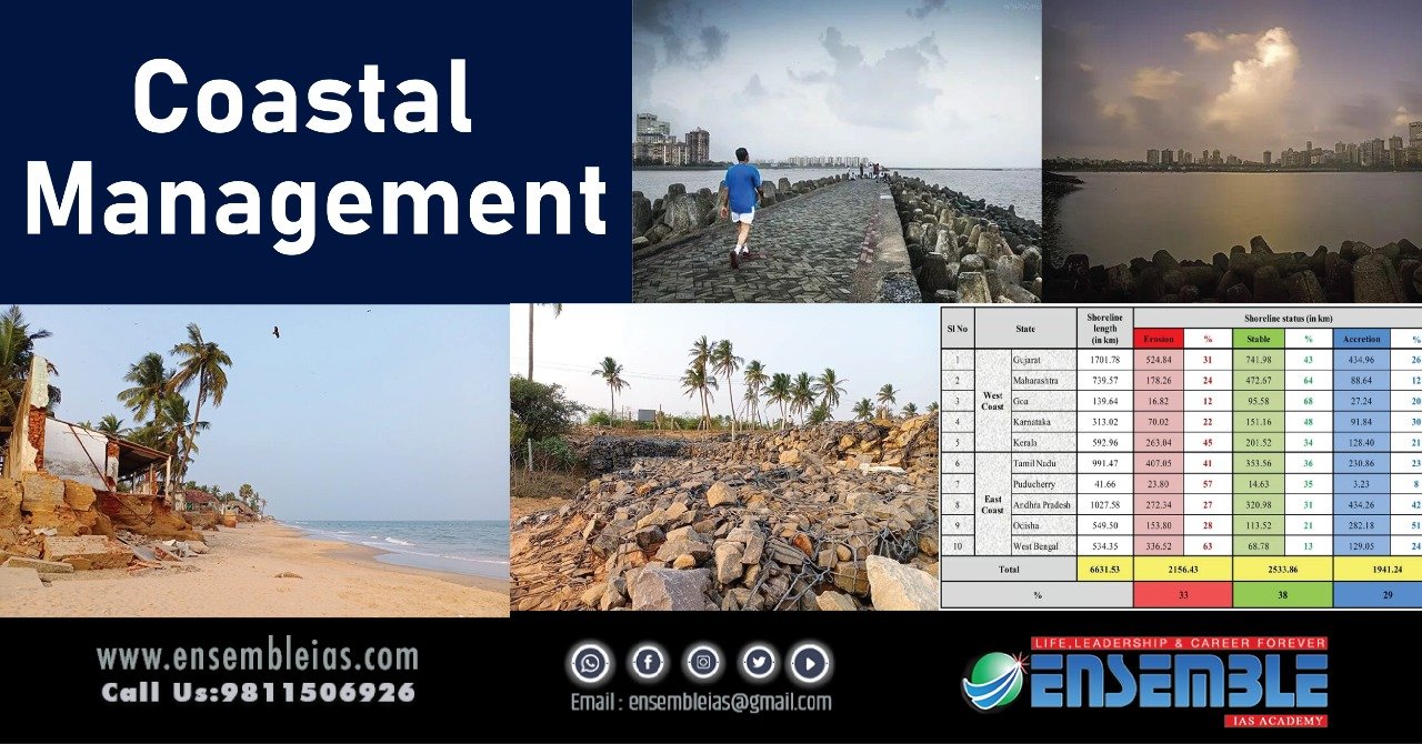
Erosion in India
- Oceans cover 70% of Earth. Over 60% of the global population lives along the coastline. India has a coastline of more than 8,100 km
- People living along this coastline are affected by the effects of climate change. Between 1990 and 2016 in India, nearly 34% of India’s coastline was under varying degrees of coastal erosion.
- Sea erosion in places is about between 1 to 10-15 meters per annum. The shoreline had advanced by 600 meters compared to where it was in 1975. Status of state-wise Shoreline changes along the Indian coast (1990-2016) showed one out of three as eroded, one in accretion, and only one as stable
Effects
- Fast-rising sea levels, inundation of saltwater, tsunamis, sedimentation, flooding, and an increasing number of severe cyclones.
- Super cyclone Amphan that hit India in May last year is ranked fourth in the 2020 global list of climate disasters. The costliest tropical cyclone of the year with financial losses costing around 1 lakh crores.
Geotubes
- Indian government deals with such impacts using Geotubes. Engineered structures that are tube-like sacks filled with sand and sometimes covered with gabions–a wire box filled with small rocks. Constructed between the high- and low-tide lines. Temporary solution requiring maintenance
- Geotubes increase erosion in areas that lie outside the length of the Geotube. When you strengthen a part of the beach, the waves tend to attack the next weakest part. Only the erosion site shifts
Tetra-pods
- Type of structure used to prevent erosion caused by weather and used to enforce coastal structures such as seawalls. Can be seen on the Marine Drive in Mumbai
- When a wave breaks into this boundary, a portion of its energy is absorbed by the rocks. Being porous, they let some water flow around, rather than against it. Each one weighs around 2 tons.
Mangroves
- Preserve mangroves. Their roots run very deep and the way they grow, they act as a soft barrier for waves and break up wave energy
- During the super cyclone that hit coastal Odisha in 1999, villages located behind mangroves suffered less damage than those located within embankments and those which had neither mangroves nor embankments
Estuaries
- Estuaries are wetland bodies of water usually found where rivers meet the sea. Estuaries are home to unique plant and animals that have adapted to brackish water—a mixture of freshwater draining from the land and salty seawater
- Estuaries act like huge sponges that buffer and protect upland areas from crashing waves and storms and preventing soil erosion. They soak up excess water from floods and stormy tidal surges driven into shore from strong winds.
Also Read: Corpse Flower Why in news?
Other methods
- Groynes: Walls are built perpendicular to the coastline outwardly curved away in the opposite direction from downdrift. It protects the coast because the accumulated sand filters and absorbs wave energy.
- Offshore breakwater: Concrete blocks and/or boulders are sunk offshore into the sea. This alters wave direction and filters wave and tide energy
- Floodgates: Storm surge barriers prevent damage from storm surges that could harm the area they protect. They can be opened and allow free passage, but close if there’s a storm surge. Eg Thames Barrier
- Beach replenishment: Uses sand sourced from elsewhere that is added to the existing beach. Requires repeated applications on an annual or multi-year cycle